



Ag Weather Forum
Labor Day Weekend Forecast: Some Heat Relief for Eastern US, But Continues to Be Hot in Central US
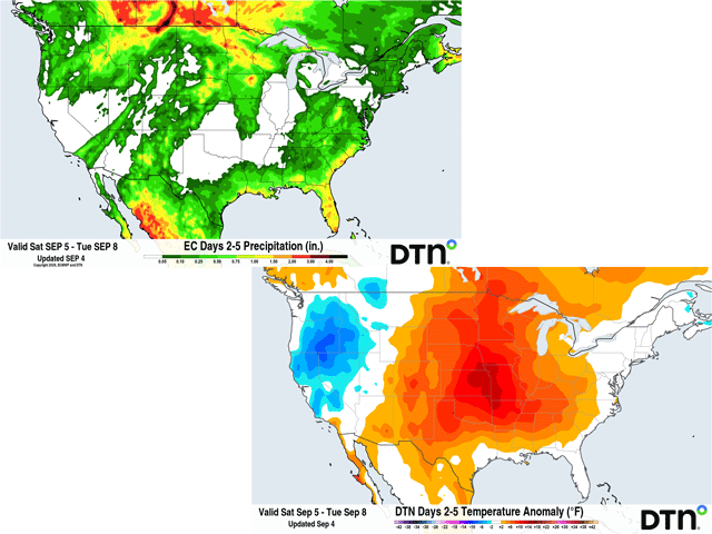
Meteorologists would say we're already in the fall season as of the start of September while astronomers will wait until the equinox on Sept. 22. Many Americans take the Labor Day holiday as the unofficial final weekend of summer. It is a big holiday known for outdoor activities like picnics, grilling, and water sports, as well as family gatherings and good times to celebrate while the outdoors are still comfortable. Maybe my growing up in Minnesota brings about these feelings more so than for southern folks, who have hot weather continuing for quite a while yet. But still, this is an important weekend for outdoor activities, and the forecast is important for those plans. How does this year's "end-of-summer" weekend look across the country? Let's take a regional perspective around the country.
PACIFIC NORTHWEST VERY WET AND COOL THIS WEEKEND
What has been a rather hot and largely dry summer is breaking this week as we have seen a couple of storm systems bring through widespread rain and milder temperatures. In general, a storm system will be sitting over the top of the region all week long. There will be some breaks in the rain and clouds, but not many. Some areas of flooding will be possible, which will help with the drought, but may make the outdoors a little treacherous. Temperatures will be cooler than normal, largely in the 60s and 70s in the valleys, and cooler up in the mountains.
SOUTHWESTERN US LARGELY MILD AND MOSTLY DRY
The Southwest monsoon continues to bring areas of showers and thunderstorms to the region, but has been focusing largely on the Four Corners area so far in September. That is expected over the weekend. However, Hurricane Maria, which is well southwest of California and will not get anywhere near the coast, may still send some moisture northeast into California and Nevada on Sunday. Otherwise, those two states will largely be dry and mild for the weekend, a nice combination to enjoy the outdoors.
NORTHERN PLAINS AND UPPER MIDWEST SEEING AREAS OF SHOWERS
P[L1] D[0x0] M[300x250] OOP[F] ADUNIT[] T[]
The storm track has been active on the northern edge of an upper-level ridge across the Northern Plains and Upper Midwest this week. We've seen areas of showers and thunderstorms and some severe weather, though the coverage has not been all that impressive. Such is the case for this weekend as a front remains stalled in the area and a system coming from the Pacific Northwest will move into the region on Sunday and Monday. The best coverage and intensity from this system looks to stay north in Canada, but there could be some areas of heavy rain and severe weather to watch out for.
Temperatures will be variable depending on the rain and the nearby front and system, with the highest heat, in the 90s, concentrated across South Dakota. Some areas in Montana and Minnesota may only reach up into the 70s over the weekend, making for some mixed conditions.
SOME HEAT RELIEF FOR GREAT LAKES, EAST COAST THIS WEEKEND
A front has been stuck across the southern Great Lakes for much of the week, which has produced showers there and extended them eastward into the Northeast and Mid-Atlantic at times as well. That front will be pushing southward over the weekend, producing some more areas of showers and thunderstorms, but gradually getting drier from north to south over the weekend.
Some milder air will infiltrate these regions behind the front as well, turning a lot of the upper 80s and 90s into upper 70s to middle 80s, a much more comfortable weekend for enjoying the outdoors.
LARGE AREAS OF CENTRAL US REMAINING HOT AND DRY
A large heat dome has been situated over the Central and Southern Plains across the Southeast throughout the week. Temperatures have been generally in the 90s with some locations up over 100 degrees, especially from north Texas into Kansas. That heat will remain rather widespread for the entire weekend. Overnight lows may not push down into the 70s very often, making it incredibly hot and somewhat dangerous for people to be outside. Heat advisories and warnings are posted for most areas of these regions through the weekend, though the Southeast will see the northern front push in and take the extreme heat away. But from Texas to Nebraska and southeast Alabama, temperatures will remain quite hot.
The heat comes with very little to probably no cloud cover or precipitation. Some far western areas toward the Rockies may find a few spotty showers at times, but rainfall will be hard to come by for a lot of areas this weekend. While that will make it easy to plan an outdoor activity or barbecue, it won't offer much relief from the heat.
GULF COAST, FLORIDA DODGING SHOWERS ALL WEEKEND
Areas around the Gulf Coast and across Florida have seen a lot of rain in the last week. That included when Tropical Storm Edouard moved through eastern Texas and far western Louisiana, dumping huge amounts of rain in a small area, leading to flooding. These areas will remain under the influence of the Gulf throughout the weekend. Daily showers and thunderstorms will be rather frequent in the afternoons, but spotty coverage will make it difficult to plan a beach day or outdoor event. Some areas will get rained out while others may get lucky and dodge the showers. The frequent rainfall and winds off the Gulf will keep temperatures up in the upper 80s and lower 90s while humidity will continue to be very muggy and uncomfortable, but showers could bring down those temperatures at times and may lead to a nice evening or two in some areas.
To stay up to date with weather conditions and your local forecast for free from DTN, head over to https://www.dtnpf.com/…
John Baranick can be reached at john.baranick@dtn.com
(c) Copyright 2026 DTN, LLC. All rights reserved.