



Ag Weather Forum
Soil Moisture Used Up From Last Week's Heat Wave; Concerns Building on Expanding Drought
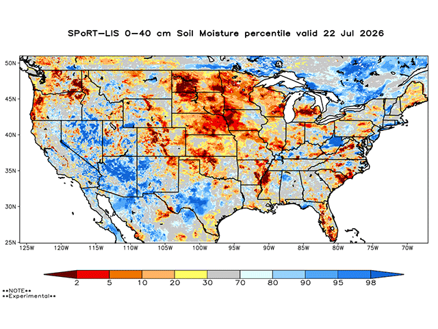
Last week's long-duration heat wave broke records in portions of the Northern Plains and made outdoor life miserable across adjacent areas of the Central Plains and Midwest. The heat has broken and cooler air has now settled across the Corn Belt, but a significant impact to soil moisture should be noted. That could result in expanding dryness and drought conditions on Thursday's U.S. Drought Monitor update. The massive heat wave of mid-July may be over, but its impact may just be starting to show up.
The heat was extensive across the Dakotas almost all last week. The region was on the edge of the heat, though, and parts of Montana and northern North Dakota saw a front settle in and keep the heat down. But across South Dakota and Wyoming, temperatures were up near or over the century mark from July 11-20. Heat was not as intense or as long lasting farther south across the Central Plains or Midwest, but much of the U.S. Corn Belt saw significant heat for mid-July.
Unfortunately, it did not come with all that much rain, either. Typically, we see rainfall on the edge of the heat dome, but that occurred in western Montana and up into Canada. The heat wave also ended with disappointment as showers were scant across the Western Corn Belt and only spotty across the Eastern Corn Belt, the portion of the region that saw the fewest days of intense heat.
As a result of the high heat and limited precipitation, soil moisture has quickly fallen, especially in the North-Central states. According to data from NASA, extremely below-normal soil moisture exists across much of the Dakotas, Nebraska, Minnesota, western Iowa and Wisconsin as of early Wednesday morning, July 22. Many of these states saw declines in their reported crop conditions this week, though for most crops the drop in conditions was generally a couple of percentage points.
P[L1] D[0x0] M[300x250] OOP[F] ADUNIT[] T[]
Part of this region was already dealing with dryness before the heat began. From northeast Nebraska into southwest Minnesota and adjacent areas of southeast South Dakota and northwest Iowa, rainfall has been below normal for at least the last 60 days and in some cases dates back to 2025. It hasn't been completely dry, and rain before the heat wave did reduce some of the drought in this area slightly, but rainfall has been harder to come by here than most other places of the Corn Belt.
With all that in mind, it should be no surprise if Thursday's update to the U.S. Drought Monitor showcases expanding dryness and drought across at least the western half of the Corn Belt, and possibly some eastern areas as well. Keep in mind that drought is a lagging indicator and conditions could be worsening more rapidly than the U.S. Drought Monitor indicates.
Some beneficial conditions are developing for some of the Corn Belt, though. The front that ended the heat wave has stalled from Colorado to Arkansas. North of this front, it is much cooler and temperatures may have a hard time getting into the lower 80s for the next few days. That will reduce stress for crops. And because the front has stalled, small disturbances moving along the front will likely produce scattered showers. We are currently seeing showers move across southern South Dakota and Nebraska early Wednesday morning. A few more rounds of showers will hit similar areas through Friday, July 24, but expand into southwestern Iowa, northeastern Kansas, and continue through large portions of Missouri as well. That will help to increase soil moisture and ease drought and limit its expansion.
However, that is the only area looking at consistent rainfall through early August. Other disturbances and fronts are forecast to move through the Corn Belt, but models are not producing a lot of widespread heavy rain. Instead, small clusters of thunderstorms will produce some winners and losers in that regard.
Temperatures will be variable going forward as well. Though some extremely cool air has settled in now, temperatures will be rising in the Plains on Friday and Saturday and spreading eastward this weekend. Though other fronts moving through could bring in some more mild air, hotter temperatures at times could lead to more acute bouts of heat stress should the rainfall not come with it.
To stay up to date with weather conditions and your local forecast for free from DTN, head over to https://www.dtnpf.com/…
John Baranick can be reached at john.baranick@dtn.com
(c) Copyright 2026 DTN, LLC. All rights reserved.