

Ag Weather Forum
Early Spring Pattern Producing Wild Swings in Temperatures, Significant Precipitation
As we near the end of meteorological winter and head into spring at the turn of the month this week, the weather pattern is certainly becoming more active.
Typically, when we think of early spring, we think of rising temperatures, the reduction of snow across the north and potentially wild swings in weather. Heading out of the cold and toward the warmth of summer, significant changes in the ambient weather are common and expected. Over the next week or so, though, the changes will be extreme.
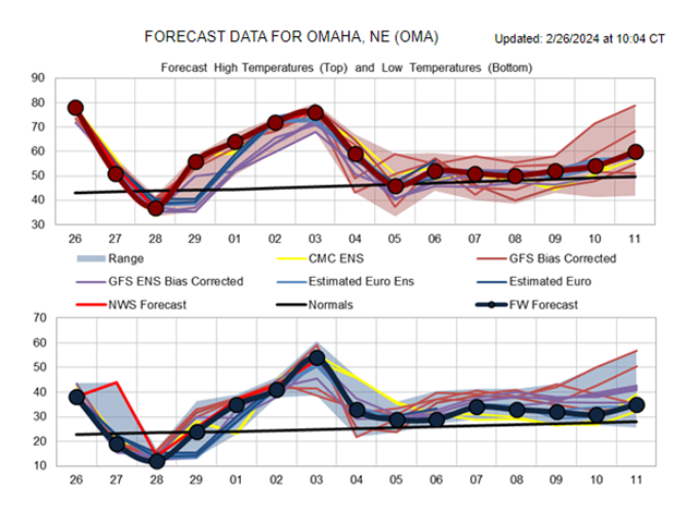
Take for example Omaha, Nebraska. The high temperature today is about 80 degrees Fahrenheit. However, a cold front coming through on Tuesday will mean a sharp drop in temperatures and potential for snow in the evening when temperatures will go down to about 30 degrees. Chicago will go from a high of 70 on Tuesday with thunderstorms and potentially severe weather to 30 degrees and a risk of light snow by Wednesday morning. Oklahoma City will drop from a high of 85 on Tuesday to 51 on Wednesday. Nashville will go from 70 on Wednesday to 52 on Thursday. Cleveland will drop from 59 on Wednesday morning to 30 by the evening with light snow.
The good news is that the cold snap will last about 36 hours in most locations and up to 48 hours in others. As quickly as the cold sweeps through the country, the warmth will return almost as quickly. Omaha may have a high of just 39 degrees on Wednesday but will warm up to almost 60 on Thursday. Chicago will go from 30 on Wednesday afternoon to 44 on Thursday. Oklahoma City will rebound from 51 on Wednesday and Thursday to 70 on Friday. Nashville will rise from 52 on Thursday and 56 on Friday to 70 on Saturday. Cleveland will move from 38 on Thursday to 50 on Friday.
P[L1] D[0x0] M[300x250] OOP[F] ADUNIT[] T[]
In addition to temperature drops, the cold front will also come with scattered showers and areas of both snow and thunderstorms. Most of the snow should be light and under 2 inches, though a heavier streak of snow will develop in North Dakota on Monday night and into northern Minnesota on Tuesday. Total amounts in that streak could eclipse the 6-inch mark.
Ahead of and along the cold front, thunderstorms will develop in the Midwest and those could turn severe with a slight risk from the Storm Prediction Center for Feb. 27 from eastern Missouri through southern Michigan. Hail looks to be the biggest threat, though strong winds and tornadoes will also be possible.
And with the extreme drop in temperatures also comes stronger winds. While not extreme like in some spring storms, wind gusts over 35 mph will be common in a lot of areas and over 55 mph in the High Plains, downsloping off the Rocky Mountains. With some drier conditions out there, the winds could elevate the risk of wildfires.
And to snap back even more during this wild rollercoaster ride of temperatures, over the coming weekend temperatures will rise even more. Another couple of days of extreme highs are expected for the first few days of March. Highs could reach up to 70 degrees as far north as Minneapolis and over to Detroit on Sunday and Monday, respectively.
However, yet again, another system is forecast to move through the West this weekend and roll out into the Plains on Sunday and then press eastward March 4-5. The system is likely to produce similar impacts with strong winds, potential for snow, strong-to-severe thunderstorms and temperature fluctuations.
Temperatures will again take a tumble, though exact highs following the system are yet to be determined. Still, the coldest temperatures look like they will stay out in the western states while those in the East will remain above normal, even after the system moves through. That leaves the middle of the country closer to normal.
Temperatures may stagnate a bit more in that range going into mid-March. As of today, the overall upper-level pattern does suggest a more prominent western trough and eastern ridge. That trough will likely send pieces of energy underneath that ridge after March 6, so we could see a continued active pattern. But with much of this air coming from the Pacific, temperatures may have less of an extreme whiplash than what we are about to see over the next week. It should be mentioned, though, that it is now spring and weather systems can get a little turbulent, causing more intense swings than what models predict, especially in the long range.
**
To find more weather conditions and your local forecast from DTN, head over to https://www.dtnpf.com/…
John Baranick can be reached at john.baranick@dtn.com
(c) Copyright 2024 DTN, LLC. All rights reserved.