Ag Weather Forum
Drought Expected to Continue in Missouri River Basin
The latest drought status update for the Missouri River Basin, prepared by a collaboration between NOAA and USDA, calls for drought to either continue or deepen in the north-central United States because of heat and dryness. The Drought Status Update covers the following states in the Missouri River Basin: Colorado, Kansas, Iowa, Missouri, Montana, Nebraska, North Dakota, South Dakota and Wyoming.
Highlight points of the report: According to the U.S. Drought Monitor, drought remains across 40% of the states within the Missouri River Basin, affecting portions of Kansas, Nebraska, North Dakota, Montana, Minnesota, Iowa, and Missouri. Only 19% of the region has less drought now than at the start of the year.
Severe to exceptional drought (D2 to D4) remains entrenched across Kansas (43% of the state) and Nebraska (28% of the state).
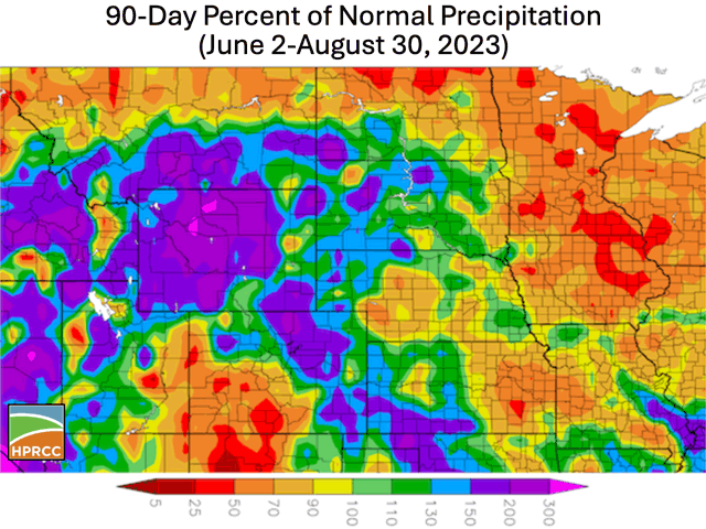
Drought continued or deepened in parts of northern Montana and North Dakota, along with eastern parts of the basin (Iowa, Missouri, eastern Kansas, central Nebraska), because of rainfall totals that were well-below normal, along with above-normal temperatures in some areas. Northern North Dakota and Montana have had conditions get worse during the last eight weeks.
P[L1] D[0x0] M[300x250] OOP[F] ADUNIT[] T[]
Current drought impacts across the worst drought areas (Kansas, Nebraska, northern North Dakota, northern Montana, Missouri, Iowa and Minnesota) include limited soil moisture for vegetation and potential crop yield reduction, poor pasture conditions forcing supplementary feeding for livestock, reduced surface water on streams and ponds or lakes, and water quality issues for livestock ponds in North Dakota. USDA Drought Disaster Designations have been declared for 88 counties in Nebraska and 84 counties in Kansas.
Runoff has been near normal on the Missouri River, but due to the ongoing drought conditions, the U.S. Army Corps of Engineers has reduced the service level to conserve water. The current service level is 35,000 cubic feet per second (cfs), which is 1,500 cfs (4%) below full service.
After a significant heat wave during the week of Aug. 21, the weather cooled starting Aug. 26, but a spell of near-to-record heat returned to start September, which was stressful to crops and livestock.
Forecasts as of Sept. 5 suggest above-normal precipitation and an easing of hot conditions in portions of the region. This prospect will be closely watched for drought easing. If improved precipitation fails to verify, potential impacts include the continuation of the current situation, stressing soybeans in their critical growth stage, along with hastening crop maturity with potential yield loss, as well as an increased fire risk.
More details from the report are available here: https://www.drought.gov/…
Bryce Anderson can be reached at Bryce.Anderson@dtn.com
Follow him on X, formerly known as Twitter, @BAndersonDTN
(c) Copyright 2023 DTN, LLC. All rights reserved.


