

Very Cold Weather for Brazil Crop
Frost Potential for Vulnerable Brazil Corn Next Week
Safrinha (second-season) corn in Brazil has been dealing with some drier conditions since early May, though that is typical for this time of year. Soil moisture has been falling and taking some of the top-end potential away from yields. That has mostly been factored into most production forecasts. But there is another risk to the crop -- frost.
Much of the corn planted in the south-central states of Brazil (Mato Grosso do Sul and Parana) were planted very late due to wetness at soybean harvest time. According to the government of Parana, this corn is still largely immature at only 6% mature and ready to be harvested. The bulk of the crop is in the fill stage at 56%, but 35% is still in the pollination stage.
The crop is very vulnerable to frost damage if temperatures fall below the freezing mark. We can reasonably assume that even though we do not have the exact numbers, that the state of Mato Grosso do Sul is in the same situation. It is a risk that occurs every year, but more pronounced when coming out of La Nina conditions during the Southern Hemisphere summer and when the crop is planted late.
P[L1] D[0x0] M[300x250] OOP[F] ADUNIT[] T[]
A front is moving through Argentina on June 9 and will push into southern Brazil over the weekend. Forecasts point to it getting deeper into central Brazil next week. The front will bring some helpful showers to the region with some forecasts calling for more than 50 millimeters (about 2 inches) in some spots. With corn still immature, it will be mostly helpful rains.
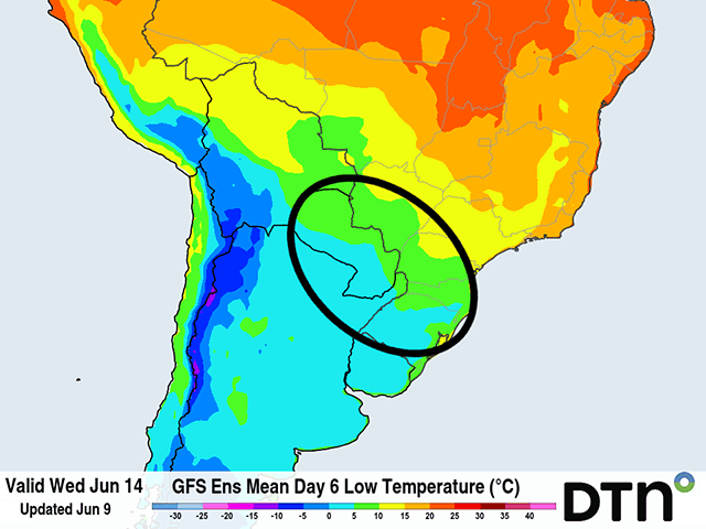
But the temperatures behind the front are going to be very cold. Forecasts from both the American GFS model and European ECMWF model have temperatures getting into the mid-to-upper single-digits Celsius (upper 30s to middle 40s) on the mornings of June 13-15. That is not quite cold enough to produce frost but does show some potential. Models usually do not do a great job of nailing low temperatures in an arctic airmass several days out and there are risks that models are not showing cold enough with the coming air.
Part of that difference is, due to model uncertainty to cloud cover and wind speeds, they tend to overdo both at times. Clearer skies and calmer winds allow temperatures to bottom out much lower than models seem to suggest and there is certainly a risk there. Falling an extra 5-10 degrees C from where models currently have them is not out of the question under the right conditions. Safrinha corn in Paraguay and the state of Mato Grosso do Sul is most at risk according to models at the moment. But that risk could spread to the state of Parana and deeper into central Brazil should the forecast push the front a bit farther north and skies to be more clear.
Though not a certainty, a frost at this stage of the growing season would be devastating to safrinha corn in Brazil and could send markets in a tizzy trying to assess the impact on global supplies following the USDA World Agriculture Supply and Demand Estimate (WASDE) due out Friday morning.
To find more international weather conditions and your local forecast from DTN, visit https://www.dtnpf.com/….
John Baranick can be reached at john.baranick@dtn.com
(c) Copyright 2023 DTN, LLC. All rights reserved.