

Ag Weather Forum
Next Two Weeks of Weather Favors Planting, Early Growth
Monday's Crop Progress Report from the USDA was being watched closely for the potential positive impact for winter wheat across the Southern Plains. Unfortunately, the heavy rain that did fall in the region had little impact on wheat conditions in the region.
From Colorado to Kansas south through Texas, good-to-excellent ratings only marginally improved, by three to five percentage points. For Nebraska, those ratings fell by seven percentage points and negated some of the gains. It is unfortunate that wheat is likely too far gone to have benefited from the rainfall, but there is still some time if rains continue.
Part of the issue is still soil moisture. Even after the rains fell, topsoil moisture improved significantly, but subsoil moisture only marginally improved across those four states. And the benefits to Kansas, the highest wheat production state, were the lowest of the four states.
P[L1] D[0x0] M[300x250] OOP[F] ADUNIT[] T[]
It has also been a much colder stretch of weather, particularly across the north, for the last couple of weeks. From Montana to Michigan, planting progress is below the average pace for this time of year for all three major crops (corn, soybeans, and wheat) and almost all secondary crops as well. Only Michigan has a higher-than-average pace for sugar beet planting. All other crops are behind the average pace. To the south, all states are at or ahead of the typical planting pace with few exceptions and mostly with regard to cotton and peanuts, which are a little more mixed.
You can find more information from the USDA's report here, https://www.dtnpf.com/….
With farmers already behind pace and antsy to get into their fields, it should come as no surprise that a forecast increase in temperatures across northern zones is likely to get planters rolling at more significant pace during the next couple of weeks. The warmup has already started in the Northern Plains and Canadian Prairies where temperatures approached or exceeded 80 Fahrenheit from Montana into Alberta on May 1 with an upper-level ridge residing over the region. That ridge will expand eastward this week and bring temperatures on a slow but even increase across the eastern half of the country. Folks that were waiting out frost potential are likely to get into their fields this week as long as it is not too wet. And that will likely be the case for much of country. Except for parts of North Dakota and around the rivers in the Upper Midwest where flooding has been an issue, topsoil moisture is generally near or below normal. That should not be a limiting factor for planting this week. But it does underscore a need for more rainfall, especially across the Plains and western Midwest, where outside of the Southern Plains areas that got heavy rain last week, rain has been at a reduced rate for the last couple of weeks.
That meant dry conditions across central Illinois. With tillage equipment able to roll with no issues and moderately strong winds on May 1, that led to blowing dust and a major multi-vehicle accident on Interstate 55. You can read more about that tragedy here: https://www.cnn.com/….
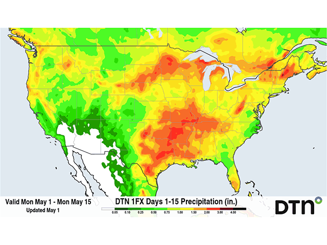
But the forecast is favorable in this regard as well. A trough in the West is increasing upward motion in the southwestern Plains starting May 2 that should expand north and east into the Northern Plains and Midwest this week. Showers may be scattered and largely disorganized, but will be around. Some areas of heavier rain are also expected, one of them being across the southern Midwest from eastern Kansas through Kentucky and Tennessee May 4-6 and another across the Dakotas into Minnesota with a system May 5-7. That should help to increase soil moisture for some of these areas either dry or in drought. It may also limit some planting for those that do not get to it before the heavier rains come. And some areas are likely to be missed due to the scattered nature of the storms. But these chances do not end this weekend, they should continue through next week as well.
Overall, with rising temperatures and continuous periods of rain across a good portion of the primary U.S. cropland, this is a good situation to be in for the first half of May if you are a farmer or rancher. That goes for seed already in the ground as well, with rain likely to move through from time to time.
To find more weather conditions and your local forecast from DTN, head over to https://www.dtnpf.com/…
John Baranick can be reached at john.baranick@dtn.com
(c) Copyright 2023 DTN, LLC. All rights reserved.