

Ag Weather Forum
Six Things to Know About a Developing El Nino
El Nino is knocking on the doorstep, and you have certainly been hearing more about it in recent weeks. Sea-surface temperatures in the tropical Pacific Ocean had been lower than the long-term average for two and a half years, but they have been abruptly changing in recent months. That was indicative of La Nina, a global driver of weather conditions that led to major heat and drought implications for many areas of the world. La Nina ended in March and forecasts have been calling for the other side of the El Nino Southern Oscillation (ENSO) -- El Nino. Instead of sea-surface temperatures being lower than the long-term average, El Nino occurs when sea-surface temperatures are higher than the long-term average.
The development of El Nino will take some time, though recent models and trends have been accelerating the process for summer 2023. This change in sea-surface temperature will have a profound effect on global weather patterns. Here are six main takeaways about the developing El Nino.
1. Temperatures are changing in the Pacific Ocean.
Temperatures are never static anywhere on the globe and that is true about temperatures in the oceans as well. There is a normal ebb and flow of temperatures that lag behind the changing sun angle across the equator. However, thanks to satellites and other data, we can track this change and average out where these temperatures should be at any given time. If we subtract where temperatures are now from where they average over the last 30 years, we can see how anomalously high or low the sea-surface temperatures are.
These anomalies are what meteorologists and climatologists track to indicate whether or not the Pacific is in El Nino (above-average temperatures) or La Nina (below-average temperatures). But where do meteorologists look? There are four regions in the tropical Pacific Ocean we can look at. You can find an image of that here: https://www.ncei.noaa.gov/….
The ENSO 3.4 region is the one that is used most typically to track these temperature anomalies, and the basis for NOAA's Climate Prediction Center to classify the current phase of ENSO. But other regions could indicate El Nino-type tendencies outside of that 3.4 region. For instance, the Nino 1+2 region has been very warm going back to February and would be classified as an El Nino already. It is also the precursor to the coming El Nino, and gives meteorologists confidence that El Nino will be developing over the next few months.
The other variable to factor in is time. Since temperatures change on a daily and weekly basis, it makes more sense to average out the variability with time. Therefore, most meteorologists look at 3-month temperature values instead of daily or weekly ones. So, even if temperatures are indicative of El Nino today, it may take several weeks of this continued trend to officially classify ENSO in the El Nino territory.
2. The jet stream will change drastically.
P[L1] D[0x0] M[300x250] OOP[F] ADUNIT[] T[]
So why does a change in ocean temperature affect weather across the globe? The reasoning is tied to thunderstorms and their effect on the jet stream. The jet stream is what produces and guides weather systems across the globe.
Warmer waters tend to develop larger and more intense thunderstorms. When the warmer waters are closer to the central or eastern Pacific Ocean instead of the central and western Pacific, the source of energy is in a completely new place. Thunderstorms add energy to the atmosphere and guide the jet stream to a different location.
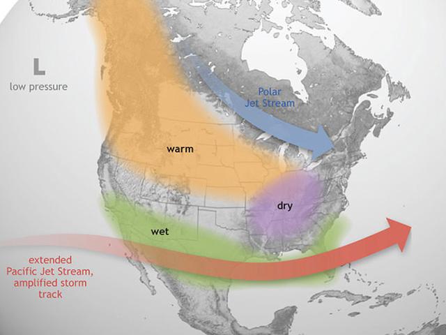
The main effect, especially in the wintertime, is to split the jet stream near the U.S. and make the southern stream of it -- the subtropical jet stream -- stronger and more active than the northern, polar jet stream. That more active jet to the south shifts where storm systems develop and track. Of course, this is not a persistent effect -- other weather factors go into how weather develops across the world -- but it is the largest driver.
3. The effects are strongest in Northern Hemisphere winter than in the summer.
Jets develop because of strong changes in temperature across an area. Since the temperature changes are more dramatic in the wintertime than the summertime, jet streams are typically stronger in the winter. That means the El Nino (and La Nina) have more of an effect during Northern Hemisphere winter than summer.
You can read more about how jet streams develop here: https://www.weather.gov/….
4. The southern tier of the U.S. ends up wetter.
With the southern jet stream being the stronger of the two after the split, the southern stream ends up being the main driver. More frequent and stronger storm systems will come from the influence of the subtropical jet stream across the southern tier of the U.S. than across Canada and the northern tier of the U.S. This usually results in systems slamming into the California coast, moving through the Southwest U.S., then redeveloping across the Southern Plains, moving through the Southeast, and occasionally turning into Nor'easters for the Northeast. Increased systems should increase precipitation in these areas, that have been very dry due to La Nina in the last couple of years. We should see a turnaround in conditions after El Nino puts its stamp on the pattern.
5. The Central U.S. ends up warmer.
With the subtropical jet being more of the weather driver, the polar jet tends to have less of an influence on the pattern. Therefore, the middle of the U.S. north through the Canadian Prairies typically ends up with warmer conditions. Systems still move through, so precipitation is typically near normal, but with warmer temperatures, snowpack is usually less. This is the opposite of La Nina, where this region usually ends up colder than normal. This would generally mean a shorter winter season and extended growing season.
6. Every El Nino is different.
While these are the typical weather patterns that develop during El Nino, every El Nino season is different. Subtle changes in the sea-surface temperatures within that zone of the Pacific Ocean, the influence of ocean temperatures in other parts of the Pacific, Atlantic, and Indian Oceans, drought, and snow cover are just some of the reasons that the weather can deviate from this typical path. Therefore, while the outlook for the U.S. may be beneficial, the actual weather that occurs may be somewhat different.
**
To find updated radar and analysis from DTN, head over to https://www.dtnpf.com/…
John Baranick can be reached at john.baranick@dtn.com
(c) Copyright 2023 DTN, LLC. All rights reserved.