Ag Weather Forum
Northern Corn Belt Sees Moisture Benefit From Heavy Snow Cover
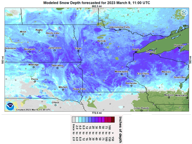
It's certainly going to be a while before fieldwork gets started in the northern Corn Belt. A conveyor belt of snowstorms during the past winter and into this early spring has spread a blanket of around two feet of snow in a swath running close to 700 miles west to east from the central Dakotas to the Great Lakes. And there's more moisture on the way with an active weather pattern still in effect. DTN Ag Meteorologist John Baranick outlines that scenario here: Models Ease Cold, Increase Precipitation This Week (dtnpf.com)
This thick snow cover is not going unnoticed by farmers. The first of May is just over seven weeks away, and the snow has to melt then muddy fields have to dry up in order for machinery to get going. "Just this week I have heard more farmers starting to discuss potential delays in spring planting in Minnesota, especially with a major snowstorm potentially forecast this week," noted Kent Thiesse, senior vice president-farm management at MinnStar Bank in Lake Crystal, Minnesota, in an email to DTN.
However, this heavy snow cover is on ground that was dry in many areas during the past couple years. In addition, the soil is not frozen very deeply. This combination allows for some improvement in soil moisture, according to state climatologists who responded to DTN inquiries about the snow cover effect.
P[L1] D[0x0] M[300x250] OOP[F] ADUNIT[] T[]
"Much of the central and Western Corn Belt went into winter with drier soil profiles after a particularly dry summer and fall," said Iowa State agriculture department Climatologist Justin Glisan in an email response. Glisan also highlighted how Iowa had its fourth-wettest meteorological winter season (December-January-February) in 151 years of records. "Recent rainfall and melting snow produced widespread ponding on fields and running tile lines," he wrote. "With warmer conditions, we noted that these ponds disappeared days after, which leads us to believe the frost depth is shallower and soil profiles are getting deeper infiltration."
North Dakota State Climatologist Adnan Akyuz agrees with Glisan's observation on how dry conditions going into winter led the thirsty ground to soak in much of the snowpack moisture. "We have to keep in mind that the soil was extremely dry getting into the winter. Depending on the sequence of thaw and melt, a good amount of melt should infiltrate into the soil to mitigate the soil moisture deficit. Furthermore, runoff should fill dugouts and water holes, given that gradual melting," Akyuz noted.
Time is still on the side of farm ground drying out in time to offer fieldwork progress. "As we warm up ... we'll see drying, especially as we enter windier months; April is climatologically the windiest month for Iowa," said Glisan. Minnesota farm management expert Thiesse has a similar perspective. "Our rivers, streams and lakes (that) were very low last fall have a lot of capacity to handle snow melt," Thiesse said. "We have pretty good capacity to take on some soil moisture. A week of 60-degree weather would change the outlook in a hurry!" he emphasized.
Fifty days or so still leaves plenty of time for planting progress issues to develop, but for the northern Corn Belt, snowpack and mud in the first half of March are generally seen as favorable. "Overall, the wetter conditions and improving drought situation are welcome news given three years of widespread drought," said Glisan.
Bryce Anderson can be reached at Bryce.Anderson@dtn.com
Follow him on Twitter @BAndersonDTN
(c) Copyright 2023 DTN, LLC. All rights reserved.


