

Ag Weather Forum
Polar Vortex Chill May Hinder Fieldwork Start
Updated forecasts for the 2023 spring season are out, and the general call is for values to be below normal -- in short, cool -- for March and April. The suggestion is that fieldwork for this year's row crops could have a delayed start.
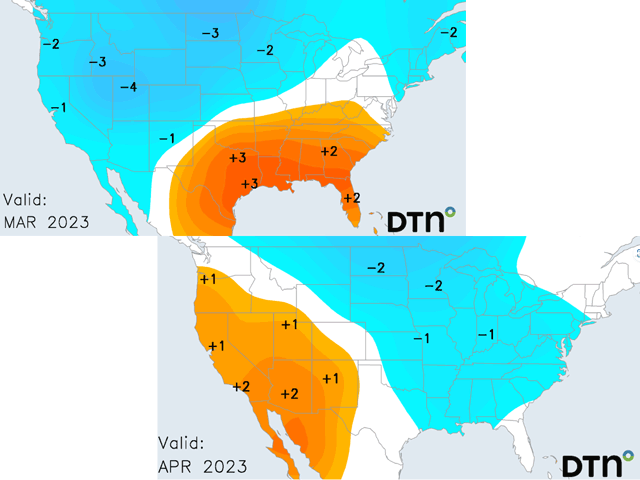
A review of DTN's March and April temperature forecast maps shows some fairly sizeable departures from normal on the cool side. Average temperatures in March in the Northern Plains show as much of 3 degrees Fahrenheit below normal with 2 degrees F below normal in the northern Midwest and in the Pacific Northwest, and as much as 4 degrees below normal in the Intermountain West. The remainder of the Midwest and the central Plains have near normal temperatures, with the Southern Plains and southeastern U.S. showing mainly 1 to 3 degrees F above normal.
April, however, expands the coverage of lower temperatures to encompass almost the entire central and eastern U.S. with readings of 1 to 3 degrees F below normal. Coolest conditions are again indicated in the northern crop areas. Meanwhile, warming moves to the western third of the contiguous U.S. This pattern leans toward a delayed start to row crop fieldwork and planting for 2023.
P[L1] D[0x0] M[300x250] OOP[F] ADUNIT[] T[]
Factors leading to this cooler forecast include the persistence of La Nina in the Pacific Ocean, even though La Nina is weakening; an active occurrence of the Madden-Julian Oscillation (MJO) moving around the globe; and the effect of a cold spell due to a polar vortex disturbance around Feb. 20 caused by a Sudden Stratospheric Warming (SSW) event.
DTN long-range forecaster Stephen Strum made this comment about the polar vortex outbreak in a seasonal forecast comment Feb. 15:
"A major polar vortex disturbance will take place before (Feb. 20), which will be considered a Sudden Stratospheric Warming (SSW) ... The winds will remain well-below normal through most of March, so this disturbance will have staying power ... This is playing out in a similar fashion to the event in late February 2008 with regard to both timing and disturbance type ... It took almost three weeks from the SSW date in 2008 for the impacts to make it down to the surface and it looks like it will be similar this time."
Weather service agency comments about spring forecast also reflect the expected impact of these large-scale drivers. "The SSW and so weakening of the stratospheric polar vortex and more variable/meridional (north to south) jet stream makes the potential for arctic air outbreaks in the northern hemisphere more likely in March," wrote NOAA Climate Prediction Center forecaster Jon Gottschalck in an update posted Feb. 16.
So, in summary: Long-range and intermediate-range ocean and atmospheric trends point to a cool start to spring 2023 in most primary crop areas, suggesting at least some delay in planting.
DTN Ag Meteorologist John Baranick has more details on the upcoming SSW event. See "What Does a Sudden Stratospheric Warming Event Mean?" at https://www.dtnpf.com/….
Bryce Anderson can be reached at Bryce.Anderson@dtn.com
Follow him on Twitter @BAndersonDTN
(c) Copyright 2023 DTN, LLC. All rights reserved.