

Ag Weather Forum
Polar Vortex Spreading Arctic Cold Next Week
In the midst of a strong winter storm, it might seem odd that my focus is on what is going to happen with a blast of arctic air next week. True, blizzard conditions across the Northern Plains and severe weather across the South may be more timely to discuss, but I already wrote about that on Friday: https://www.dtnpf.com/…. Not much has changed from when I first wrote about it, a testament to the certainty that this pattern is bringing.
But during the weekend, all models jumped on board with another significant weather feature: the polar vortex. Their depictions in the upper levels of the atmosphere certainly keyed in on this arctic blast before they actually showed the low temperatures. A strong ridge developing over northeastern Canada and Greenland was forcing a storm system to undercut it across the United States, hence our major winter storm this week.
However, by the end of the week, another ridge forms up by Alaska. In between the two ridges, an arm of the polar vortex will squeeze down into the U.S., invading the middle of the country and bringing a clipper system with it.
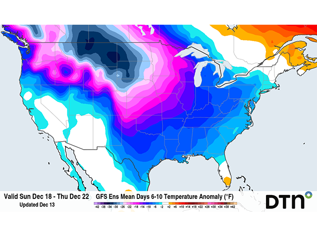
This is the start of what we usually see during La Nina winters -- clipper systems coming down from the Canadian Prairies, spreading cold, arctic air throughout portions of the U.S. Not every one of these clippers is due to the polar vortex, but this one will be. A clipper looks to move into the North-Central U.S. Dec. 18-19. The rush of cold air behind it should spread through most of the country during the following two days. With an upper-level trough already in place, the cold air will find no ridge to resist its advancement. Typically, warmer air would keep the cold front penetrating too far south. This time, it will dig deeper. Another disturbance will follow later next week as the clipper train keeps going.
P[L1] D[0x0] M[300x250] OOP[F] ADUNIT[] T[]
Precipitation is still being determined by the models. There are wide variations on how a precipitation will develop along the cold front, or even if it will develop much at all. It would be hard to believe such a strong push of cold air would produce little to no precipitation with it. But it would also be hard to believe in a very strong winter storm that winds up like the one this week is doing. Instead, it is more likely to be a mixture of the two. That goes the same for the second system.
However, with these fronts digging far to the south, that opens the door for more of the country to end up with wintry precipitation, including the Southern Plains and Lower Mississippi Valley. I mentioned that in my regular blog last week about how this is the type of pattern that could promote winter weather farther south than is typical. You can read that one here: https://www.dtnpf.com/….
So just how cold will it get? Of course, that depends on where you live. The harshest cold will be in the Northern Plains and Canadian Prairies. Models suggest that average temperatures will be 30-40 degrees below normal on a few of the days next week, or well-below zero Fahrenheit. High temperatures may not reach into positive territory.
Farther south and east, the cold will not be as harsh but still be bitter. Lows below zero will be possible across the Central Plains and Upper Midwest and could even make a run at portions of the Southern Plains, too. With wheat already in bad shape in the region and perhaps not very winter hardy, temperatures this cold without a blanket of snow could cause some winter kill. Some models do put down some protective snow cover with that first front, but the concerns should be noted.
And the cold may last a while. Last week, models made the suggestion that the pattern would relax some for the last week of the year. Now, however, they are lasting farther into January with their colder look. I guess we should not be surprised. La Nina likes to create these types of patterns. And usually, they last for an extended period before breaking down. As we get deeper into the winter season, the word clipper may become all-too-familiar, as well as the presence of the polar vortex -- just as it was the last two winters in La Nina.
To find updated radar and analysis from DTN, head over to https://www.dtnpf.com/…
John Baranick can be reached at john.baranick@dtn.com
(c) Copyright 2022 DTN, LLC. All rights reserved.