
Ag Weather Forum
Active US Weather Pattern Building From Strong Canadian Ridge
Snow lovers looking for chances of a white Christmas will get several chances during the next few weeks, thanks to an active pattern -- a multitude of storms are expected to push through the U.S. in the coming weeks, with considerable precipitation developing with each system.
So which areas have the best chances for precipitation and where might shots of cold Arctic air hit?
The impetus for the activity and inclusion of cold air to make snow will come north of the international border as a ridge of high pressure develops this weekend that should last for at least the next two weeks.
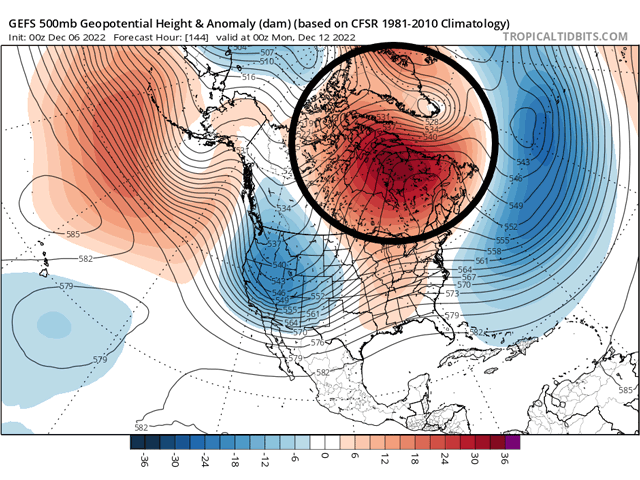
Currently there is an upper-level trough across Canada. It is very cold underneath that trough. As of Tuesday morning, temperatures in the Canadian Prairies were well-below zero Fahrenheit. Some areas were under extreme cold warnings because of wind chill values or minus 40 to minus 45 Celsius.
Though some near the border are definitely on the cold side, that trough is not falling deeper south through the U.S. this week. Instead, the trough will shift north during the next few days, weakening as it does so. A ridge of high pressure to its east over Greenland will do the weakening and take its place over Hudson Bay and northeast Canada by this weekend. That ridge is forecast to stay roughly in place for the following week and quite possibly the rest of December.
P[L1] D[0x0] M[300x250] OOP[F] ADUNIT[] T[]
When a ridge gets that strong, storm systems cannot pass through them or push them out of the way, they must go around them. Being so far north, storms are forced southward, in this case moving through the U.S. The supply of storm systems is quite numerous back across the Pacific and through Asia and Europe to allow a multitude of storms to push through the U.S. in the coming weeks.
These storms will likely carry some decent precipitation with them with each passage. Storms will move into the Rockies and upon coming out, will deepen and grow, pulling up moist air from the Gulf of Mexico as they pass eastward through the country.
We should see plenty of precipitation developing with each system. The subsequent rainfall will help water levels on the Lower Mississippi River and ease drought conditions for the eastern half of the country.
However, these storms are likely to pass right over the western Plains, and southwestern Plains in particular, with limited precipitation. Hard red winter wheat areas that are in deep drought may not see any drought easing out of this pattern, even though it is very active. The southeastern Plains through the Tennessee or Ohio Valley will likely benefit the most.
The pattern also suggests colder weather. With high pressure over the northern reaches of the globe, the tendency will be for it to spread out farther south. The access to colder air may not be arctic in nature with every storm system, but a few of them could bring down some of the more impressive cold shots, especially for the Northern Plains and northwestern U.S.
The switch in the pattern will be fairly evident with the first large storm system moving through early next week. Ahead of the storm, temperatures will increase east of the Rockies. Some areas as far north as Chicago could hit the 50-degree mark on Dec. 13 before the storm moves in. Thunderstorms, some severe, will also be possible with the storm, as well as strong winds.
Behind the large system though, temperatures will drop at least to near normal. Areas in the Northern Plains and Northwest should go back below normal with better access to colder air and potential for snowfall. With stronger winds behind the storm, there is some indication that blizzard conditions will come to the Northern Plains.
With more and more systems passing through behind this initial system, the colder air will penetrate deeper and deeper across the U.S. for the rest of December. Assuming some of these systems will have plenty of precipitation as they draw moisture from the Gulf of Mexico and access to cold enough air, more widespread snowfall should be the result. It is impossible to indicate where and how much, but those across southern locations should be on alert for some types of wintry weather to be possible.
One caveat that we will need to keep in mind is that nothing is guaranteed. Storm track is the most important factor for getting snowfall in your location. Systems passing off to the north of your area are likely to be rain rather than snow, especially if you live in the Southern Plains or Southeast. But if you are looking for a white Christmas, this is the type of pattern you want to see unfolding in early December.
**
Have you signed up yet for the 2022 DTN Virtual Ag Summit Dec. 12-13? You can join me as continue the talk about the weather patterns and conditions expected for the 2023 growing season. Get all the information you expect from DTN, from the comfort of your home or office! For details on the agenda and how to register, visit www.dtn.com/agsummit
John Baranick can be reached at john.baranick@dtn.com
(c) Copyright 2022 DTN, LLC. All rights reserved.