

Ag Weather Forum
Storm System Produced Some Improvements to Drought
A strong storm system entered the Pacific Northwest on Oct. 21. During that weekend, precipitation spread across the region as a mix of valley rain and mountain snow. Precipitation then spread out into the Northern Plains and winds increased across the Central and Southern Plains. As the system exited the Rockies on Oct. 24, precipitation increased across the Southern Plains and widespread rains fell through the middle of the country early this week, increasing soil moisture in some of the most drought-stricken areas of the country.
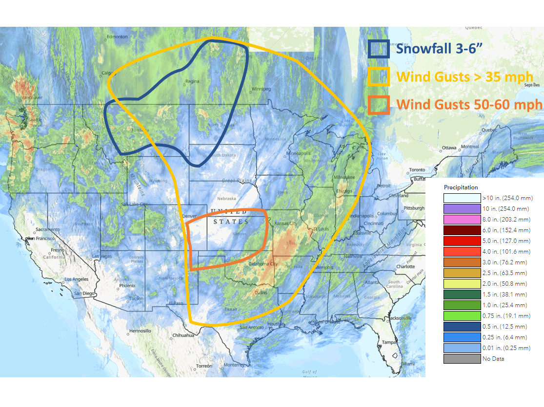
One of the most significant features of the storm system was the winds, even if they were brief. As the system moved into the central Rockies on Oct. 23, winds in the Plains increased significantly. Widespread wind gusts of 50-60 miles per hour were noted in Colorado and Kansas but wind gusts over 35 mph were noted up and down the Plains, into the Canadian Prairies, and western Midwest as well. Winds caused blowing and drifting of dust in these areas and spread a few wildfires as well. The intensely strong winds died down that night into Oct. 24, but still remained elevated on the backside of the low-pressure system across the Northern Plains and eastern Canadian Prairies as well as behind a secondary low-pressure center in the Midwest and northern Delta.
Those northern locations had enough access to cold air to turn rain over to snow as the system wrapped up. Areas in eastern Montana and the western Dakotas into southeastern Saskatchewan and western Manitoba recorded snowfall mostly in the three- to six-inch (seven- to 15-centimeter) range. There were some locations in Saskatchewan that did see more with reports of 30 to 40 c, (11 to 15 inches) in Moose Jaw and 20 cm (about 8 inches) in Strasbourg.
P[L1] D[0x0] M[300x250] OOP[F] ADUNIT[] T[]
To go along with the snow, many northern locations also saw plenty of rain. With 1.12 inches (28.5 millimeters) of rain, Winnipeg exceeded its record for precipitation in a year with another two months left to add to that record. That comes just two years after the city's driest year on record. Soil moisture improved over many parts of Montana, North Dakota and the Canadian Prairies, areas where drought had been increasing in recent months.
Farther south, precipitation increased rapidly on Oct. 24 across Texas and Oklahoma as the cold front was moving through. The system was able to stream moisture off the Gulf of Mexico. It also ingested the remnants of Hurricane Roslyn that struck the Pacific Coast of Mexico on Oct. 23 and rode over the Mexican Sierra Madres to add additional tropical moisture to the system. Moderate to heavy rain erupted from central Texas and Oklahoma to Wisconsin and Michigan, including widespread areas of over 1 inch of rain through some of the most drought-stricken soils in the country from Texas through Oklahoma, eastern Kansas, Missouri, Illinois, and northwest Arkansas. In this area, amounts over 2 inches were also fairly common.
The water is helping to replenish soil moisture and could fill in some of the rivers. The southern half of the Mississippi River, which is at historically low levels, will only benefit slightly. Some of the heaviest rains fell over the Red River Valley, which is not a tributary of the Mississippi. The Arkansas River runs into the Mississippi River south of Rosedale, Mississippi. That is closer to the terminus of the river than where it is needed farther up.
Still, the impacts will limit the continued decline of the river for at least a period of time. As far as the drought, the rainfall is a step in the right direction for the Southern Plains into the southwestern Midwest, but the deepness of the drought will take more than just one event to create significant improvement.
Areas in the rest of the Midwest and Tennessee Valleys that were in much less severe drought could see marked improvements on the next update or two of the U.S. Drought Monitor.
To find more regional weather conditions and your local forecast from DTN, head over to https://www.dtnpf.com/…
John Baranick can be reached at john.baranick@dtn.com
(c) Copyright 2022 DTN, LLC. All rights reserved.