

Severe Windstorm Possible Monday
Severe Windstorm Potential for Northern Illinois
A cold front moving through the Upper Midwest is producing some showers and thunderstorms in Iowa in increasing coverage on the morning of Aug. 29. As thunderstorms grown and move into northern Illinois, they'll find increasing heat and humidity to fuel storms which may become severe. A couple of severe thunderstorm warnings have already popped up in Iowa.
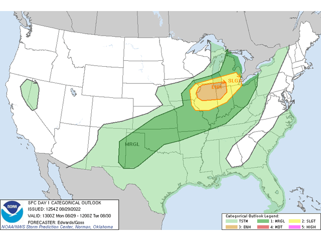
The Storm Prediction Center has labelled the area with an "Enhanced" risk of severe storms, mostly due to strong wind gusts. In their discussion, the Center notes that "at least sporadic severe wind gusts are expected through the day as a complex of thunderstorms organizes this morning in Iowa, then proceeds eastward through the afternoon across northern Illinois and perhaps extreme southern Wisconsin ... Whether or not the event technically meets derecho criteria, a swath of strong-severe convective wind is expected ... Some gusts may reach significant (65+ kt) speeds, capable of locally substantial damage."
P[L1] D[0x0] M[300x250] OOP[F] ADUNIT[] T[]
To classify as a derecho, the storms would need to cover a wide area at least 400 miles long, contain wind gusts over 58 mph along the length of the 400 miles, and include a few gusts over 74 mph (hurricane strength). That may be tough to do, but widespread severe wind damage at this stage of crop development, when corn is in its late-fill or maturing stages, would be catastrophic. It would also be coming to some of the most productive soils in the country that have had some of the best weather conditions for growth this summer.
If you live in or around this area, pay special attention to the weather today to keep yourself, family, and coworkers safe.
The Storm Prediction Center has yet to issue a severe thunderstorm or tornado watch for the area, but they may issue one prior to 12 p.m. Central Time based on current radar and model trends.
To find updated radar and analysis from DTN, head over to https://www.dtnpf.com/…
To see tips on how to prepare for extreme weather such as derechos, see https://www.dtnpf.com/…
John Baranick can be reached at john.baranick@dtn.com
(c) Copyright 2022 DTN, LLC. All rights reserved.