
Variable Rains for South America Wheat
Wheat in Southern Brazil, Argentina Get Some Improved Soil Moisture
While central Brazil, an area dominated by corn this time of year, is seeing an early start to its dry season and decreasing soil moisture as that corn gets into and through its pollination period, southern Brazil and Argentina will have opposite conditions.
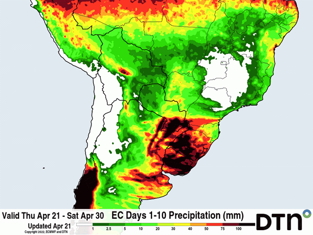
Several waves of showers and thunderstorms will develop across southern Brazil from the state of Parana southward all the way through Argentina's primary growing regions. Safrinha (second-crop) corn in the state of Parana should see beneficial showers as more and more of that crop gets into pollination and it is in a stark contrast to the corn crop farther north in central Brazil. But wheat areas from the state of Rio Grande do Sul through central Argentina are set to receive estimated amounts of 30 to 75 millimeters (1.2 to 3 inches) through the end of April. Some areas are likely to exceed those totals with the state of Rio Grande do Sul and Uruguay to receive more than 100 mm (4 inches) in some areas.
While these areas were consistently dry for the early growing campaign from September through February, showers have been picking up recently, especially in southern Brazil. Soil moisture has been on the increase and that has had a significant impact on crops currently in the ground.
P[L1] D[0x0] M[300x250] OOP[F] ADUNIT[] T[]
According to the Department of Rural Economics in the state of Parana, ratings for corn are listed corn as 97% good and have been hovering around that mark for the last several weeks. Reports from the Rosario Grain Exchange in Argentina are reporting that yields are coming in better than expected given the drought, a testament to the recent rains and their impact on the later-planted corn and soybeans.
But that also means that soil moisture across these areas is improving for winter wheat planting. That is getting underway in some areas but will start in earnest at the beginning of May. Soil moisture as the crop starts to get planted should be more than adequate for germination and early development.
The question will be whether or not that increase in precipitation will last. The DTN forecast, along with both American and European models, suggest that this will only be a temporary boost to soil moisture in the regions.
For May, indications are that rainfall will fall below normal, though the degree to which is not consistent between the forecasts. But the overall picture should be for areas to see either near- or below-normal precipitation for the month.
May is typically on the lower end of the scale area-wide in terms of total precipitation, so it is usually difficult to get improved soil moisture during the month anyway. And having below-normal precipitation is somewhat of a double-edged sword. While rainfall is usually pretty light, having reduced rainfall in May does not mean that it is unusual to have large dry stretches during the month. Producers should be used to a drier month ahead. However, that does mean the increase in soil moisture should be temporary and soil moisture should be on the decline for May. Wheat usually does not need an abundance of moisture to get started, so decreasing soil moisture is not an overly large concern until the crop gets into the spring months starting in September.
To find more international weather conditions and your local forecast from DTN, head over to https://www.dtnpf.com/…
John Baranick can be reached at john.baranick@dtn.com
(c) Copyright 2022 DTN, LLC. All rights reserved.