

Ag Weather Forum
Drought Relief Chances Drying Up
It has been a very active pattern during the last several weeks. Rainfall amounts across the Northern Plains and Upper Midwest have been more than June and July's total precipitation in some cases.
There have been some negatives that have come with the rain as well. Localized flooding broke out in some of the heavier showers across northern Iowa and eastern Nebraska as well as in some of the better off areas in Illinois and Ohio. The rain came via clusters of thunderstorms which sometimes involved severe weather reports of strong winds and large hail. You can read about some of that damage over the last 10 days here: https://www.dtnpf.com/…. The damage has not been as widespread and horrific as the derecho that moved through Aug. 10, 2020, but those that have been hit have suffered irreparable damage being so late in the season that crops simply are too weak to recover.
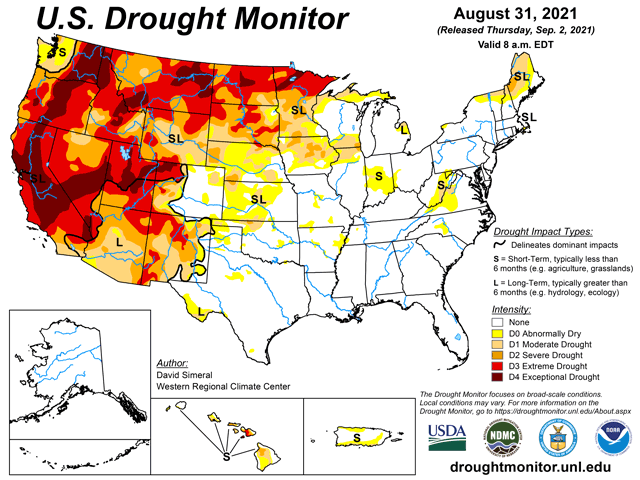
Drought has been reduced on the latest Drought Monitor across a wide area in the Upper Midwest. It may or may not have been enough to improve conditions for crops that were dealing with drought all summer long, but it will help to set up next season's crops in better shape, at least compared to what the situation was in early August. However, with the drought being so deep this year, it will likely persist through the winter, even if above normal precipitation occurs this fall and winter.
P[L1] D[0x0] M[300x250] OOP[F] ADUNIT[] T[]
One more system will give it a go to try and reduce drought conditions. It started to form in the Canadian Prairies Aug. 31. It slowly brought a cold front into the Northern Plains on Sept. 1 with some moderate rain. That has continued through the Dakotas and Nebraska into Minnesota and Iowa Sept. 2.
The system starts to lose its steam thereafter with more minor impacts across the rest of the Corn Belt. The exception may be over Kansas where the front will be slow to move south, and showers will be more numerous through Sept. 4.
Here in Kansas, drought has been steadily increasing as summer showers have been missing spots on occasion. The state needs more rainfall to ensure proper seed-to-soil contact in establishing winter wheat after planting. The same goes for Oklahoma and Texas as temperatures have been high this week in the 90s Fahrenheit with some occasional peaks around 100 degrees. Soil moisture has been on a general decline in these states as well.
But after this system moves through the country and finally peters out, the country looks to turn much quieter. There will be another small system that moves through the Plains and Midwest Sept. 6-7 but may only have some localized showers instead of being widespread.
A ridge will be trying to develop across the West like we saw for much of the summer. Models are unsure whether or not it will be strong enough to hold back the continued push of disturbances across the North Pacific, but it will try.
We may see some more disturbances moving through the Corn Belt for the rest of September, but it is not likely to be to the degree we have seen over the last few weeks. The days are getting shorter, temperatures continue on a downward trend, moisture is leaving the air, crops are drying down. The fall season is "officially" upon us, if you go by meteorological fall that started Sept. 1. The chances for significant reduction to the drought across the Western Corn Belt are waning like the sun.
John Baranick can be reached at john.baranick@dtn.com
(c) Copyright 2021 DTN, LLC. All rights reserved.