

Ag Weather Forum
Three Storms to Bring Rainfall to Western Corn Belt
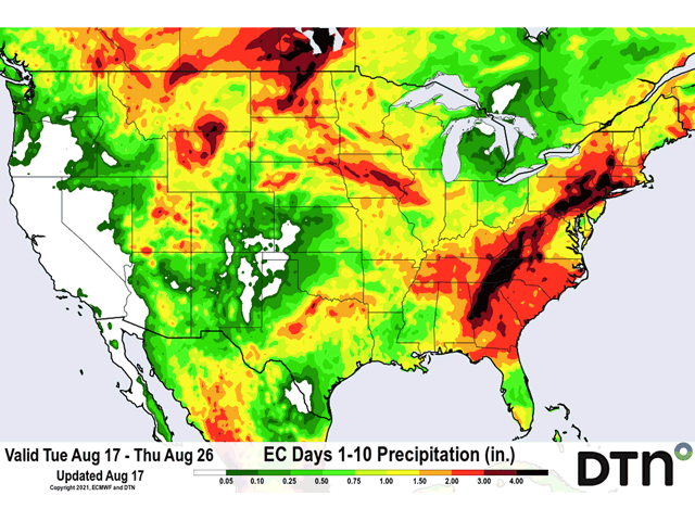
The setup that produces the best chances to see significant rainfall across the Northern Plains is a trough in the West with a ridge in the East. The trough provides the storm systems that come out of the Rockies. The ridge provides the moisture as it pulls humid air northward from the Gulf of Mexico.
The setup during the next 10 days will not be perfect, but it will be the best chance the region has seen for several rounds of rain since the early spring.
Three disturbances will move into the West or Pacific Northwest in succession during the next week and each one will produce a storm system that moves through the Northern Plains. What we have typically seen this summer has been a few frontal boundaries that have moved through with no real anchor in the West to provide widespread lift and organization for thunderstorms. Last week saw a bit of a change, but the troughs moved more into Central Canada instead of the West. As they moved through the Northern Plains, they did produce some showers, and areas of moderate rainfall were noted in some areas. That led to good-to-excellent crop rating increases in both corn and soybeans across North Dakota last week, but was not enough to stave off areas of dryness in South Dakota, Nebraska, Minnesota or Iowa -- states that all saw ratings decline.
P[L1] D[0x0] M[300x250] OOP[F] ADUNIT[] T[]
That setup did produce good rainfall for the Eastern Corn Belt, however. And although good-to-excellent ratings declined a bit in Indiana, and Illinois after a large increase the week before, conditions for filling corn and soybeans continue to be quite good and many of these states could be closing in on record yields.
You can read more about those estimated yields in the 2021 DTN Digital Yield Tour coverage here: https://www.dtnpf.com/….
But the Western Corn Belt is finally getting more into the pattern it needs to produce good rainfall. The first storm is starting to dig into the West on Aug. 17. It will be joined by two more during the coming weekend. The first storm is set up to be the best of the three. Good moisture streaming northward along with hot weather will produce lots of instability to produce thunderstorms.
As the first system moves out of the Rockies Aug. 19, the combination of strong upper-level dynamics and surface instability should result in fairly widespread showers and thunderstorms across the Western Corn Belt through Aug. 20. Storms are likely to be severe in some cases, but producers will likely take the good rainfall with the chances for storm damage. As the system moves eastward on Aug. 21 into the Eastern Corn Belt, it should lose some intensity, a rare event to occur so far this summer.
The following two storms may not have the greatest coverage or intensity of storms, but the scattered showers should add to the rainfall totals and may help to fill in some gaps that occur with the first storm.
Like I mentioned above, before the storms get into the region, it is going to be hot. It already has been in the Dakotas and Montana where 100-degree-Fahrenheit readings have been noted during the past couple of days. And temperatures will likely stay up there until that first system moves through. The heat and continued dryness have led to more drought stress for the Western Corn Belt and the rainfall is desperately needed.
The pattern has turned more active for the region, however, and that looks like it might continue into September. It is too late to add to yields, but it is not too late to preserve what is still there.
John Baranick can be reached at john.baranick@dtn.com
(c) Copyright 2021 DTN, LLC. All rights reserved.