

Midwest Cleans Up After Severe Weather
Wind, Tornado Damage Hit Wisconsin But Could Have Been Worse
Editor's Note: This article was first published as a blog at 9:53 a.m. CDT July 29. It was updated at 4:30 p.m. CDT July 29.
**
MINNEAPOLIS (DTN) -- Wednesday afternoon unfolded much like meteorologists predicted when they had warned there could be severe weather, even possibly a derecho in some areas of the Upper Midwest. Heat was building, moisture was increasing, and the frontal boundaries were in place.
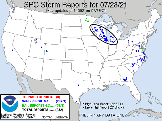
Just after 7 p.m. CDT, storms flared in the exact spots that models were predicting earlier in the day, though a tad late. They grew rapidly and people were quickly warned the storms could have potentially severe hail and wind gusts.
A few of the storms saw enough rotation to warrant tornado warnings in western Wisconsin. Bows quickly developed on the front end of the storms, and the damage paths were set across Wisconsin.
While the winds did not earn a derecho classification, the storms did produce some heavy damage across a long path through the Midwest. Many wind gusts of 60-70 mph were reported along the storm paths. Wisconsin Gov. Tony Evers declared a state of emergency to help those rebuild from the damage.
WORRIED ABOUT STORM
Ryan Nell, who lives outside of Beaver Dam in southeast Wisconsin, was very worried when the storms approached. The ample warning gave his family time to prepare for the storm. They parked as much equipment as possible in sheds, closed shed doors, and lowered grain augers to lessen the chance of high winds tipping them over.
P[L1] D[0x0] M[300x250] OOP[F] ADUNIT[] T[]
His family then spent the night in the basement as a precaution.
Nell reported some damage of lodged soybeans and a few broken tree branches. But an immediate assessment found no damage to Nell's corn, buildings, or equipment. He said that he was going to get his drone out to get a more bird's-eye view, but he was one of the lucky ones that came out relatively unscathed.
"The initial forecast put us (Beaver Dam) at the epicenter of the storm," Nell said, "but the cell came and split around us for some reason. Unfortunately, other people weren't as lucky."
WIND, TORNADO DAMAGE
He was right. They weren't as lucky. Wind damage was reported to his northeast in nearby Fond du Lac and south in Watertown. Both areas are about 20 miles away from Nell's farm.
Elsewhere in southeast Wisconsin, there may have been more tornado damage. According to the Associated Press, "The National Weather Service sent two crews to survey damage in the Jefferson County community of Concord and in the Waukesha County Village of Wales on Thursday, where the storm toppled farm buildings and left a path of destruction. Cows could be seen grazing among debris that landed in farm fields."
MOVED INTO OTHER STATES
With the strongest parts of the storm splitting near Nell's farm, the western flank of the storm took a slightly more southerly path and moved into northern Illinois while another went across Lake Michigan into northern Indiana and southwest Michigan. Both portions diminished as they moved away from the lake into more stable air Thursday morning.
Whether it was due to the western flank eating some of the energy for the main core of storms or that the winds did not line up just perfectly, severe wind gusts did not reach hurricane-force, save for one report in central Wisconsin early in the storm history.
CONDITIONS GOOD FOR SEVERE WEATHER
Nell and others were given a heads-up earlier on Wednesday about the potential for bad weather. Meteorologists saw the setup was good for severe weather on the models. A cold front was moving through the Northern Plains on the morning of July 28 and was expected to ignite thunderstorms in northern Minnesota and northwest Wisconsin in the afternoon and evening.
Those storms were forecast to move southeast along a stalled frontal boundary across Wisconsin in the evening and overnight hours. Daytime temperatures in the 90s Fahrenheit and dew points well into the 70s Fahrenheit provided ample fuel for thunderstorms to grow rapidly. And strong winds aloft were likely to push the thunderstorms along and aid in developing a "rear-inflow" jet, a way for storms to focus and prolong strong winds.
All these ingredients combined prompted the Storm Prediction Center (SPC) to issue a rare "Moderate Risk" of severe weather across much of Wisconsin into southwest Michigan. In their discussion, they used the term "derecho," which should have sparked fears about the damage that was caused in Iowa through Indiana on Aug. 10, 2020.
However, a derecho is classified as a swath of wind damage from thunderstorms that must extend at least 250 miles, include wind gusts of at least 58 mph along most of its length, and have several, well-separated 75 mph or greater gusts.
While the storms were severe and farms are left recovering Thursday from wind damage, the storms didn't meet derecho classification levels.
(See blog about original weather threat at https://www.dtnpf.com/….)
John Baranick can be reached at john.baranick@dtn.com
Matthew Wilde can be reached at matt.wilde@dtn.com
Follow him on Twitter @progressivwilde
(c) Copyright 2021 DTN, LLC. All rights reserved.