
Severe Weather Alert for Upper Midwest
Derecho Possible in Upper Midwest Wednesday
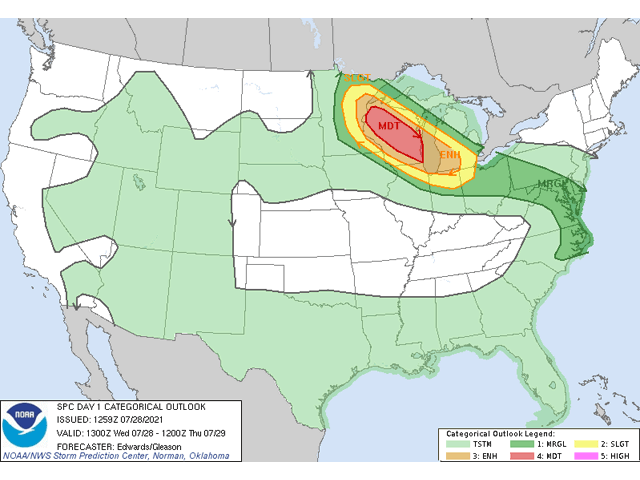
A "Moderate Risk" of severe weather alert issued by the Storm Prediction Center (SPC) is rare and is reserved for expected widespread severe weather events or those of great magnitude. The event expected late Wednesday into Thursday July 28-29 could be both. Wednesday's discussion is also breaking out strong wording from the SPC -- derecho.
The term is likely to perk up ears, especially if you recall the damage a derecho did from Iowa to Indiana on Aug. 10, 2020. Wind gusts over 80 mph were commonplace and a few over 100 mph were recorded as storm damage swept across an area over 400 miles long. Good-looking corn was wiped out and yields suffered tremendously due to the system. So this wording, even if reserved for a less crop-intensive area, will garner attention to the weather later Wednesday.
The derecho on Aug. 10, 2020, somewhat took forecasters by surprise. The SPC is making sure that if one occurs this time around, it will not surprise anyone.
P[L1] D[0x0] M[300x250] OOP[F] ADUNIT[] T[]
Thunderstorms are expected to develop along a cold front in northern Minnesota late in the afternoon or early evening. They will then travel southeast along a fairly stationary frontal boundary. This is key for derecho development. Thunderstorm clusters that move along stationary boundaries and slow-moving warm fronts are great ways for storms to continue to ingest high-energy air that contains significant amounts of moisture and heat, and produce a strong cold pool beneath itself, which maintains and strengthens its forward speed and destructive wind potential. Under the right conditions, a "rear-inflow jet" may develop on the backside of the storm complex, focusing the destructive winds and increasing their duration.
Wednesday's setup includes significant moisture with surface dew points in the upper 60s to lower 70s Fahrenheit, daytime temperatures in the 90s Fahrenheit, a mechanism to initiate storms with a cold front, and a stationary boundary for the storms to ride along. All of these ingredients together make for the potential to see initially strong supercell thunderstorms capable of significantly large hail, tornadoes and damaging winds that will grow into clusters and line storms that primarily produce wind damage. But will this be enough to classify the storms as a derecho?
A derecho is a term that describes widespread, long-lived strong winds from thunderstorms. According to the SPC, a derecho is currently classified as a swath of wind damage from thunderstorms that "extends for at least 250 miles, includes wind gusts of at least 58 mph along most of its length, and includes several, well-separated 75 mph or greater gusts." The derecho of Aug. 10, 2020, certainly fits the bill.
But the current situation may or may not reach those distinct criteria. As of 8 a.m. CDT, the moderate risk area, which is the area most likely to see the strong winds, is approximately 300 miles long. If storms can continue along that path with continuous severe wind gusts and a few hurricane-force wind gusts, we may see it officially classified as such. But if the storms tonight do not meet the exact criteria, it may not matter. Under a moderate risk, severe storms are likely to occur, and damage, primarily from strong winds, could be enough to make this event large enough to reduce production of corn and soybeans from Wisconsin, regardless of its classification as a "true" derecho.
Overnight, the storms, either in clusters or lines, will move southeast into the eastern Midwest. They may still have significant strength to them as they cross Lake Michigan into Lower Michigan and Indiana and possibly Ohio as well. If that is the case, then the derecho may be confirmed even if we do not receive reports over the lake. But there are some still some uncertainties for the Thursday morning time frame as to how strong the storms will continue to be. Regardless, this severe weather event will be one to take seriously and could have some significantly negative impacts for corn and soybeans going through reproduction.
John Baranick can be reached at john.baranick@dtn.com
(c) Copyright 2021 DTN, LLC. All rights reserved.