

Severe Storms Slam Plains, Midwest
Severe Storms Bring Flooding, Baseball-Sized Hail, Hurricane-Force Wind Gusts July 9-10
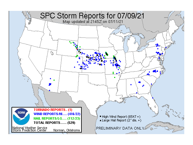
Flooding, baseball-sized hail and hurricane-force wind gusts, oh my! Yes, it was a couple of very active severe weather days July 9-10. A well-forecast upper-level disturbance deepened as it moved through a stubborn ridge in the West and into the Plains. Already working along a frontal boundary, strong thunderstorms quickly developed across Nebraska Friday, July 9, and clusters of storms continued south and east through Saturday, July 10, becoming much more isolated from Texas into the Lower Mississippi Valley July 11.
Residents around Omaha, Nebraska, saw some of the strongest winds as several reports of 75 to 90 miles per hour were sent into the Storm Prediction Center late Friday night, leading to about 200,000 customers losing power. Wind speeds that strong are equivalent to a Category 1 hurricane. Radar imagery showed an impressive and quick-moving bow echo right through town along and west of the Missouri River. Another bowing segment occurred at roughly the same time in southwest Iowa as well. More clusters provided extensive damage and strong wind gusts in central Nebraska and northeast Missouri.
Winds were not the only factor on Friday, though. Hail, some of it as large as baseballs over 3 inches in diameter, fell in a line northwest of Des Moines, Iowa, with more of the incredibly large hail scattered around Box Butte County, Nebraska, and Hancock County, Illinois.
P[L1] D[0x0] M[300x250] OOP[F] ADUNIT[] T[]
Overall, there were 416 reports of strong winds and wind damage, and 112 reports of severe hail across the country, mostly from Nebraska and northern Kansas through the Mid-Mississippi Valley.
And that was just Friday. Storms did lose some intensity on Saturday as the low slowed down and spread some of its energy a bit farther south and east across the Southern Plains and Ohio Valley. But there were an additional 144 wind reports and 12 hail reports, along with seven reports of tornadoes under the spinning low that was centered over Missouri.
The total of 560 wind reports and 124 hail reports is rather impressive for a couple of days. I should note that this also includes severe storms that happened elsewhere in the country, as well. But the main concentration was in the Central and Southern Plains eastward through the Ohio Valley.
Rainfall was also quite significant. There was some flooding across the Mid-Mississippi Valley, but rainfall amounts over 4 inches was recorded in broken segments from eastern Nebraska to western Kentucky. There was likely over 8 inches in portions of northern Missouri, where most of the flooding reports occurred.
It should come as no surprise that there will be extensive damage that came from the storms. Wind, hail and flooding will likely lead to green snap on both corn and soybeans, goose-necking of flattened corn, defoliation and nutrient deficiencies. That likely goes along with some damage to mature wheat still waiting to be harvested in Nebraska and Kansas. While some of the damage can be assessed rapidly, the total extent of the damage may take more than a week to sort out. Photos on Twitter and several of DTN's sources thus far have been sadly impressive.
John Baranick can be reached at john.baranick@dtn.com
(c) Copyright 2021 DTN, LLC. All rights reserved.