

La Nina Threshold
Pacific Ocean Cools to La Nina Level
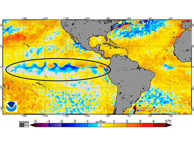
OMAHA (DTN) -- Pacific Ocean temperature analysis on June 3 shows that a La Nina cooling event is developing: It revealed a value of 0.5 degree Celsius below average. The half-degree Celsius below average is the threshold for La Nina.
La Nina is the term given when Pacific Ocean equatorial temperatures reach a sustained value of at least 0.5 degree Celsius below average. La Nina presence during the U.S. summer has been correlated to hotter and drier conditions in the U.S. Midwest and a reduction in crop yields.
The change in the Pacific equator temperatures is being watched closely by forecasters. DTN's forecast group is no exception.
"I would say that the confidence in the forecast is the biggest concern here," said DTN Ag Meteorologist John Baranick. "A true La Nina would definitely be concerning for the summer."
P[L1] D[0x0] M[300x250] OOP[F] ADUNIT[] T[]
Atmospheric features with La Nina are highlighted by upper-atmosphere high pressure over the U.S. Great Plains and western Midwest. The pace of these developments is a key for DTN long-range forecaster Nathan Hamblin.
"Much of this depends on how fast La Nina conditions take hold in the atmosphere. If the current short-term shift continues at this pace, then confidence will increase in warmer and drier conditions during the second half of summer across the Northern Plains into the Upper Midwest," Hamblin said. "If the process slows or halts and it takes La Nina longer to take hold, these dry risks wane a bit. Model guidance currently does not show these trends, but risks are there based on analogs from tropical forcing signatures."
At the very least, even a weak La Nina comes with the likelihood of regional drought staying around this summer, according to Jeff Johnson, DTN certified consulting meteorologist.
"Most likely we will see regional dryness and drought expand eastward from two existing areas of drought. Drought over southern Colorado and western Kansas will enlarge and spread east through Kansas and possibly into western Missouri by late summer," Johnson said. "Another area that is more at risk for drying out during the course of the summer would be the Northern Plains. Drought is expected to develop or worsen during the mid to late summer from the Dakotas through Minnesota and Wisconsin as rainfall becomes more sporadic."
Crop year 2020 is already showing evidence of being a challenging year on the weather scene. Articles by DTN Crops Technology Editor Pamela Smith and DTN Staff Reporter Emily Unglesbee point that out:
View From the Cab: https://www.dtnpf.com/…
DTN Field Roundup: https://www.dtnpf.com/…
A Pacific Ocean cooling trend similar to La Nina occurred in 2010 following a spring featuring overall fast-paced planting of row crops. U.S. crop weather turned drier and hotter during the last half of the season. Corn yields eventually showed a 7% decline from a then-national record of 164.7 bushels per acre in 2009 to 152.8 bpa in 2010.
Bryce Anderson can be reached at bryce.anderson@dtn.com
Follow him on Twitter @BAndersonDTN
(c) Copyright 2020 DTN, LLC. All rights reserved.