
Weatherlink
El Nino a Strong Influence This Winter
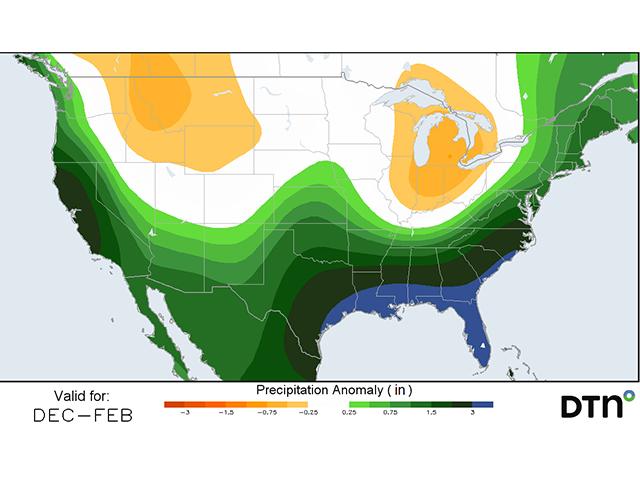
El Nino conditions in the Pacific Ocean have steadily strengthened over the fall season and will diminish going into spring. Such a strong El Nino will make for a great influence on the weather patterns across the U.S. and much of the world for early 2024. For the U.S., this means a split jet stream that often will lead to above-normal temperatures across the north and an active storm track across the south. Of course, it will not be a constant feature, and the end of the winter season could hold some surprises for us, as well. But, December has historically been a very warm month for northern and eastern areas of the country during El Nino. More variability may show up later in the season.
-- Pacific Northwest (Idaho, Oregon and Washington): For the most part, it has been a warm and wet fall in the region. Drought has been reduced but not eliminated. El Nino tends to favor warm and quieter weather, though it could be a bit more active near the coast. But, signals in the forecast for precipitation are not very strong. Therefore, we could see mixed conditions heading into spring depending on where storms eventually track. Drought will likely be a player in some parts of the region.
-- Southwest: The monsoon season was poor this summer and fall, but we did see heavy rain move through thanks to Tropical Storm Hilary, which brought record rainfall to parts of California and Nevada. El Nino highly favors increased precipitation in the region during winter, which should help to ease or eliminate the remaining drought in the Four Corners states and build ample snowpack for the start of the 2024 growing season. Because of the more active storm track, temperatures will likely be a touch below normal in many instances, but strong cold conditions are likely to be infrequent.
-- Northern Plains: An active fall pattern made for early snow in the fall but helped to ease drought conditions, as well. El Nino favors above-normal temperatures across the region during winter, leading to less heating demand and lower snowfall on average. However, it does not mean reduced precipitation, per se. The forecast through the winter should maintain relatively frequent fronts, but the main storm track will be off to the south, and so will the chances for above-normal precipitation. With El Nino waning later in the season, we could see potential for deeper cold shots in February and March, though that is speculative.
P[L1] D[0x0] M[300x250] OOP[F] ADUNIT[] T[]
-- Central and Southern Plains: The fall weather pattern was mixed as El Nino started to take control late in the season. Increased precipitation led to drought reduction in a lot of cases, and winter wheat overall is sitting in much better shape this season than the previous two falls. El Nino favors a storm track through the region this winter, leading to higher precipitation than normal for much of the region, especially farther south. Further drought reduction is likely, and increased soil moisture should favor the wheat when it awakens from dormancy in early spring. However, with the increased storm track also comes an increased risk of snowfall and wintry precipitation, which also keeps temperatures closer to or even a bit below normal for the seasonal average.
-- Coastal Texas and Louisiana: Dryness and drought have been building since the summer and have taken control during the start of winter. However, El Nino favors a southern storm track, which typically brings above-normal precipitation to the region during the winter, favorable for significantly reducing or even eliminating the extreme drought.
-- Midwest: Variable conditions led to mixed drought improvements and degradations during the fall season, but overall improvement was seen for most areas by late in the season. El Nino historically creates mixed conditions across the region, but a mild December and January are almost guaranteed. February also tends to be a warm month, but the waning El Nino and influence of other factors could lead to deeper cold shots in the month. Precipitation also tends to end up on the short end during El Nino, as does snowfall, especially if lake-effect snow cannot get going under the warmer conditions.
-- Delta: Dry conditions during the fall season led to increased drought across the region, especially on the southern end, where it has been extreme. El Nino favors a southern storm track that should bring more beneficial precipitation to the region over the winter, helping to significantly reduce or even eliminate the long-standing drought. Such an active pattern could lead to an increase in the potential for wintry precipitation but could help with water levels on the Mississippi River, which reached historically low levels this fall.
-- Mid-Atlantic and Northeast: An active pattern kept much of the region very wet during the fall, and drought areas were very minimal outside of the central Appalachians. El Nino almost guarantees above-normal moisture in December in the region, and those conditions are favored to continue for the rest of the winter, as well. However, with El Nino waning, we could see more cold shots moving through late in the season. The main storm track ends up to the south but also tends to produce more coastal systems, especially later in the season. The prediction for snowfall is a tricky one, as warmer conditions usually lead to lower snowfall amounts, but coastal systems tend to produce extreme totals.
-- Southeast: The fall season was relatively quiet and warm, which led to increased drought conditions for the region, especially farther north and west, which largely missed out on a couple of tropical features. El Nino favors a storm track right through the region during the winter season, and increased precipitation is likely, though the Tennessee Valley may not be as lucky as those farther south and east. December is usually a warm month, but the active storm track will eventually lead to more variable temperatures later in the season.
**
-- Read John's weather blog at https://about.dtnpf.com/…
-- You may email John at john.baranick@dtn.com
[PF_1223]
(c) Copyright 2023 DTN, LLC. All rights reserved.