
Weatherlink
La Nina Moisture Watch
As we move into early 2021, a Pacific Ocean cool-water La Niña event continues to dominate the ag weather scene.
Pacific sea surface temperatures have been recorded at around 1.5°C (about 2.7°F) below normal. The National Oceanic and Atmospheric Administration Climate Prediction Center is calling this La Niña event the eighth-strongest dating back to 1950. Climate forecast agencies now call for a 95% chance of La Niña to continue into the spring season. In addition, there is a high likelihood of La Niña lasting through the 2021 spring season.
WIDE VARIANCE
The likely presence of La Niña during at least the first segment of the upcoming crop season brings a wide variance in the weather pattern forecast indications across the central U.S. That difference includes above-normal precipitation during the first quarter of 2021 over the northwestern U.S. and in the eastern Midwest.
Precipitation fortunes are much different in the western Midwest and most of the Plains, where the precipitation trend is notably less -- below normal. That lower precipitation trend means that drought areas in the western Midwest and most of the Plains have a high probability of continuing that way through the spring.
P[L1] D[0x0] M[300x250] OOP[F] ADUNIT[] T[]
PERPETUATING PROBLEM
There is also the question of how long this drier pattern could affect the 2021 row-crop season.
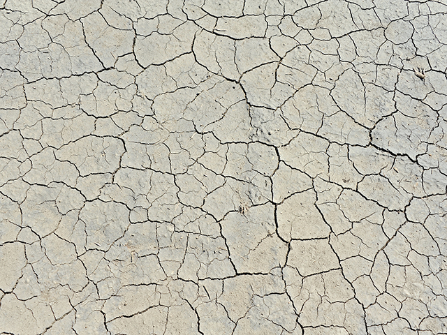
The potential is worth thinking about. Crop weather scientists note that when conditions are drier than average, the impact of that dryness could feed on itself. In other words, dry areas could get drier.
That tendency could lead to soils warming earlier in the season for fieldwork and early planting, but there is also the concern that the soil-moisture profile will not have enough to sustain crop development. In some drier areas of northwestern Iowa, for example, soil-moisture profile measurements showed only 2 to 3 inches of moisture in the five-foot profile at the end of fall harvest 2020.
POTENTIAL DELAYS
The have and have-not feature of La Niña precipitation also implies that the eastern Midwest could have the potential for heavy precipitation resulting in fieldwork and planting delays as the spring season unfolds. This very thing happened back in the spring of 2011, when a strong La Niña was in effect.
This tendency on the wetter side, coupled with the drier impact historically of La Niña in the western Corn Belt, will be closely eyed, monitored and worried over while the Pacific features evolve.
> Read Bryce's weather blog at about.dtnpf.com/weather.
> You may email Bryce at bryce.anderson@dtn.com, or call 402-399-6419.
[PF_0121]
(c) Copyright 2021 DTN, LLC. All rights reserved.