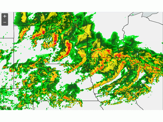
Derecho Brings Winds, Damage, Rain
Derecho Cuts Through South Dakota and Iowa, Some Damage Reported
OMAHA (DTN) -- South Dakota, Iowa and southern Minnesota were caught in another derecho system Tuesday night with high winds and heavy rains in some area, though early damage reports appeared relatively mild other than typical power outages.
Parts of southeast South Dakota saw 3-5 inches of rainfall, and the storm was highlighted on social media for the green skies it cast over Sioux Falls. Social media reports this morning also indicate some crop and structural damage in the area.
Tim Luken, general manager of Oahe Grain in Onida, South Dakota, reported 90 mph winds north of his location and damage to several bins at a local operation. "East of here a farmer lost 40 quarters to hail," he told DTN through email.
The National Weather Service on Tuesday classified the storm as meeting the description of a derecho. South Dakota weather stations reported winds reached as high as 99 mph around Howard, South Dakota, northwest of Sioux Falls. Winds across parts of Iowa hit 80 mph, though the storm weakened as it reached the eastern edge of Iowa.
The derecho was not as strong as the one that blasted through parts of the same region in August 2020.
P[L1] D[0x0] M[300x250] OOP[F] ADUNIT[] T[]
Leading into the storm on Tuesday, Iowa State Climatologist Justin Glisan noted northwestern parts of the state were facing severe to extreme drought conditions.
"Unseasonably dry conditions exacerbated longer-term drought across northwestern Iowa as stations reported little to no rainfall over the previous week," Glisan stated in a weekly Crop Progress report.
Cities such as Sioux Falls and Des Moines also had major power outages Tuesday night from the storms.
Parts of the same region continued getting showers from storm systems rolling through Iowa, Kansas and South Dakota on Wednesday.
DTN's weather outlook for Wednesday noted showers and thunderstorms continue in the forecast for northern and central crop areas Wednesday. The storms, in general, will offer beneficial rainfall for crops. Meanwhile, stressful heat remains in effect over southern crop areas, notably in the Southern Plains, Ohio Valley and Delta.
The storms could provide relief to the corn and soybean crops, which saw conditions decline last week because of hot and dry weather. As DTN cited from Tuesday's Crop Progress report, 64% of corn was rated in good-to-excellent condition, down another 3 percentage points from 67% the previous week. The current rating is now equal to a year ago. "Illinois' corn fell 5 points to 65% good to excellent, and Iowa dropped 3 points to 77% good to excellent," said DTN Senior Analyst Dana Mantini.
On soybeans, 63% were rated in good-to-excellent condition, down 2 percentage points from 65% the previous week but still above last year's rating of 59% good to excellent at this time. "Illinois soybeans are at 62%, down from 66% good to excellent, and Iowa is at 77%, down from 80% last week," Mantini said. "Nebraska soybeans are rated at just 41% good to excellent."
See "USDA Weekly Crop Progress Report, July 3" here: https://www.dtnpf.com/….
If your area suffered any major damages from Tuesday's derecho, please let us know.
Chris Clayton can be reached at Chris.Clayton@dtn.com
Follow him on Twitter @ChrisClaytonDTN
(c) Copyright 2022 DTN, LLC. All rights reserved.


