
DTN 2021 Digital Yield Tour
Tour to Assess Drought's Impact on National Corn, Soybean Yield Estimates
MT. JULIET, Tenn. (DTN) -- Drought may be the ag weather story of the season, but its impact on national corn and soybean production is up for debate, especially as regions of the southeastern Corn Belt report plentiful moisture and outstanding crop conditions.
The 2021 DTN Digital Yield Tour, powered by Gro Intelligence, aims to provide a clearer picture of national production possibilities for corn and soybeans by combining Gro's data-driven yield models with boots-on-the-ground perspective from DTN sources and experts. Beginning on Monday, Aug. 9, the tour will publish in-depth reports on 10 major corn- and soybean-producing states as well as national yield estimates.
The annual event, now in its fourth year, will start with Nebraska and South Dakota. Even though North Dakota isn't officially part of the tour, we will include information on its growing conditions because of its relevance to this year's commodity price picture. From there, coverage moves into Missouri and Kansas on Tuesday, Aug. 10; Iowa, Minnesota and Wisconsin on Wednesday, Aug 11; and Illinois, Indiana and Ohio on Aug. 12. National average yield estimates will be released on Friday, Aug. 13.
We'll publish a news article midafternoon each day during the tour as well as links to interactive displays of Gro's data. You can also contribute to the Digital Yield Tour by using the hashtag #dtnyieldtour21 on Twitter and find a collection of our ongoing coverage here: https://spotlights.dtnpf.com/….
CROP EXPECTATIONS
DTN Ag Meteorologist John Baranick said that going from a La Nina to a neutral state in the Equatorial Pacific meant that the weather was up for grabs this growing season.
P[L1] D[0x0] M[300x250] OOP[F] ADUNIT[] T[]
"We saw drought grow in the Northern Plains but fade in the Central and Southern Plains, only to return to small areas in the latter half of summer. Storm events have been few and far between for the northwest Corn Belt, but frequent in the southern and Eastern Corn Belt," Baranick said. "Severe weather has been lacking all year. That's a good thing to limit weather damage, but usually that means that rainfall was lacking as well."
Gro Intelligence senior analyst Jon Haines said the corn and soybean yield models for North Dakota, South Dakota and Minnesota are all showing corn yields below the five-year average. Soybean models appear more even with last year, although "this is because the most critical period lies ahead of us," he said. "So, we expect the models will start incorporating more damage if the drought doesn't abate."
DTN Lead Analyst Todd Hultman, who recently spoke at Minnesota Farmfest, said crops in west-central Minnesota appear to be on a tipping point. "Crops still look good enough to have potential if we got a couple of good rains in August, but if they don't, I think it's going to take quite a dive in this area."
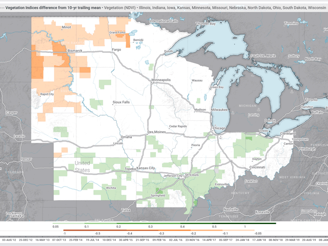
Baranick said that with all the talk about drought, it's surprising to look at the satellite data. Normalized difference vegetation index (NDVI) maps don't look bad overall. "There are pockets where you'd say it looks bad in western South Dakota, most of North Dakota, and northwest Minnesota, but there is some good 'greenness' in eastern South Dakota, southern Minnesota, and northern Iowa."
Rainfall has been more plentiful, although still variable, across Nebraska and Iowa. Both states could see higher yields than last year, Haines said. Wisconsin is also looking at beating its yields from last year.
Missouri and Kansas are also both looking at corn yields above their five-year averages, too.
"Rainfall has been pretty consistent across northern Missouri, most of Illinois, and Indiana," Baranick said. "While there have been some amazing rainfall events where over 6 inches has occurred, it's been mostly spread out. Not one spot in the state has been hit repeatedly too often. Over the past three months, these areas have had 100%-150% of normal rainfall. It hasn't been excessive, but very good."
Healthy precipitation has powered Gro's yield models and farmers' expectations of strong yield potential in Illinois, Indiana and Ohio for both corn and soybeans.
HOW THE MODELS WORK
Gro's yield models, which underpin the Digital Yield Tour, update daily as new data becomes available. The models, which use machine learning to analyze the relationships between millions of data points, start showing high levels of statistical accuracy when compared to USDA's final yield around the beginning of August. They also usually arrive at final yield estimates in mid-November, much sooner than USDA.
This year's tour also overlaps with the release of USDA's monthly Crop Production and World Agricultural Supply and Demand Estimates (WASDE) reports on Thursday, Aug. 12. The National Agricultural Statistics Service (NASS) will be releasing its first projections of U.S. corn and soybean yields, which no longer include in-field samples. From here on, USDA will update its yield and production estimates monthly before releasing its final estimates in January 2022.
Gro's crop models are based on a wide array of public and private crop and environmental data including NDVI from NASA satellite imagery, land surface temperature maps, rainfall, USDA crop condition surveys, crop calendars, planted and harvested acreage data from NASS, cropland data, U.S. government soil surveys and much more. (For more on how Gro's yield models work, please read "Data Put to the Test" here: https://www.dtnpf.com/….)
Each day, DTN will share details of Gro's yield models, including the high and low county yield estimates from each state. NDVI maps, which show how green or lush a crop appears from outer space, compose a large part of Gro's models, and while that technology is sophisticated, sometimes it just can't compare to what farmers see when they walk into their fields. That's why we include insights from farmers and other sources, including's DTN's weather and marketing experts. If you'd like to share those thoughts with us, or your own yield check results, please email katie.dehlinger@dtn.com, emily.unglesbee@dtn.com or matt.wilde@dtn.com.
(c) Copyright 2021 DTN, LLC. All rights reserved.

