

Ag Weather Forum
Widespread Showers, Severe Weather With Large Storm This Week
Following a large storm system from last week that produced widespread precipitation across the country, this week will feature another big storm. Widespread precipitation, severe weather, and some snow -- all common in spring storms -- will occur with this one as well.
The meteorological development of this storm will probably be more interesting than the storm itself as it will not follow a typical pattern of an upper-level low or trough moving across the country. However, an upper-level low WILL be involved.
A big upper-level ridge is poking up into western Canada from over the Pacific Ocean and will be pinching off a piece of energy March 12-13. The low will slide southeast through the Rockies but park itself in the Southwest through this weekend. Typically, that would mean showers moving through the mountains and High Plains with not a lot of extension eastward. However, this low will not be self-contained and will send some energy eastward for later in the week. That should allow a bigger storm system to evolve across the country with widespread precipitation for most areas almost coast-to-coast.
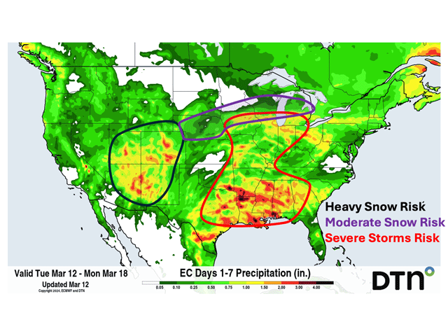
With a pretty decent push of moisture from the Gulf of Mexico and abnormally high temperatures, this will cause thunderstorms and some good rain amounts to fall. The Gulf Coast states should pick up most of the heavy rain, but thunderstorms notoriously put down heavy rainfall where they occur. That could be pronounced from eastern Texas up into Iowa and Michigan on March 14. Rainfall amounts over 1 inch are forecast where these thunderstorms hit.
P[L1] D[0x0] M[300x250] OOP[F] ADUNIT[] T[]
They will not hit all areas, of course, but for those in Missouri and Iowa that are still listed on the drought monitor, this could be an important event. That is especially true for those in Iowa still in deep drought and who missed out on last week's storm system. Soil moisture in this area is very low.
While that may be good for planting coming up in the next month, it is not for early growth and these areas will be begging for rain over the spring. This may be an important step.
Of course, when thunderstorms are mentioned in the spring, the thoughts about severe weather also need to be mentioned. And indeed, there are risks of severe weather. The same areas on March 14 will have risks of severe storms. The Storm Prediction Center (SPC) is currently targeting Iowa and northeast Texas into southwest Arkansas as the areas of greatest risk for severe storms. All hazards will be possible, but the SPC is particularly noting the potential for large hail.
On the cold side of the storm, closer to the primary upper low, snow will be a hazard. The Four Corners area will see waves of valley rain and mountain snow for several days, but upslope flow into the Rockies from the east will drive the likelihood of very heavy snow in the front range in Colorado and northern New Mexico especially. The heaviest period will occur throughout the day March 14. These types of events are usually hard to predict in terms of amounts, but in general, up to 18 inches of snow will be possible at some lower elevations up against the mountains, with higher amounts at higher elevations up to 3 feet. Downtown Denver could see more than 12 inches.
And the risk of snow may extend farther east as well. As with last week's storm that dumped some surprise moderate snow in Nebraska, this storm may do something similar. Models disagree on that risk, but as of the early morning model run of the American GFS model on March 12, there is potential for more moderate snow across Nebraska again and also northeast through Michigan on March 14-15. With temperatures being borderline here, it is another difficult forecast.
What this storm is missing from a typical spring storm is widespread strong winds. With the upper low staying away from the main storm system, upper-level winds are not going to be all that strong, which leads to the surface winds being less breezy as well. It still will be breezy, but not as extreme as a typical spring storm. Wind gusts of 30-40 mph will be possible in the Southern Plains on March 13 and the northern edge of the system across Nebraska into central Wisconsin on March 14.
To find more weather conditions and your local forecast from DTN, head over to https://www.dtnpf.com/…
John Baranick can be reached at john.baranick@dtn.com
(c) Copyright 2024 DTN, LLC. All rights reserved.
Comments
To comment, please Log In or Join our Community .