

South America Calling
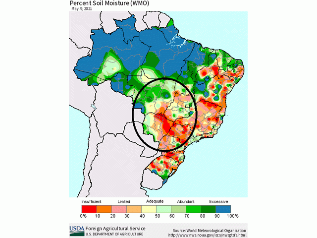
Soil Moisture Running Short in Brazil

In the primary Brazil second-crop (safrinha) corn areas, some southern locales have seen rain during this week. Satellite image estimates of up to 25 millimeters (1 inch) of precipitation fell across Parana with closer to 12 mm (0.50 inch) or less in southern Mato Grosso do Sul. The paltry rainfall is not likely to increase soil moisture much but should stabilize crop conditions that have been on a steady decline during the past month. The stabilization may be very brief, however.
Farther north, nearly no rain has fallen in the last 10 days and temperatures have been well-above normal with daytime highs in the lower to middle 30s Celsius (upper 80s to middle 90s Fahrenheit) each day. The high-water demand continues to deplete soil moisture. Satellite estimates in the attached graphic depict most of the safrinha growing regions below 40% of capacity that continues to decline week to week.
P[L1] D[0x0] M[300x250] OOP[F] ADUNIT[] T[]
The exception is across northern and western Mato Grosso. The state accounts for roughly 45% of the Brazil safrinha corn production. Rainfall has been a bit more normal across these areas earlier this season, though dryness has settled in as well during recent weeks. Corn that may be looking fine thus far in these areas could decline as well.
Weather forecast models continue to be pessimistic about rainfall chances for the next week. Both the European and American solutions have some isolated shower potential over the southern areas again through May 15, but would be highly isolated and light, offering no significant benefit. They also keep the rest of the areas to the north bone-dry into late next week.
Both models show some hint at another frontal boundary moving northward from Argentina late next week or weekend. The American model has this front stalling through central Brazil, producing promising rainfall for the last week of May. However, it should be noted that model solutions that far out are hard to trust, especially in an area that has seen severe drought developing during the last two months. As a former supervisor of mine was fond of saying, when models were trying to produce moderate or heavy rainfall in an area of drought, "When in drought, leave it out." We should note the potential, but will scrutinize it closely until we get into next week.
With the recent and forecast dryness, area agencies and the USDA have been lowering their production estimates. The USDA reduced their estimates from 109 million metric tons down to 102 mmt on their report released on May 12. On the same day, CONAB lowered their production estimates down from 108.9 mmt to 106.4 mmt.
Crops continue to get further and further into reproductive stages of growth and the moisture becoming increasingly important for yields. If that front does not produce the prescribed rainfall late next week and weekend, rainfall that may come later in June may be too late.
John Baranick can be reached at john.baranick@dtn.com
(c) Copyright 2021 DTN, LLC. All rights reserved.
Comments
To comment, please Log In or Join our Community .