

Ag Weather Forum
Will the Southwestern Plains Benefit From This Active Pattern?
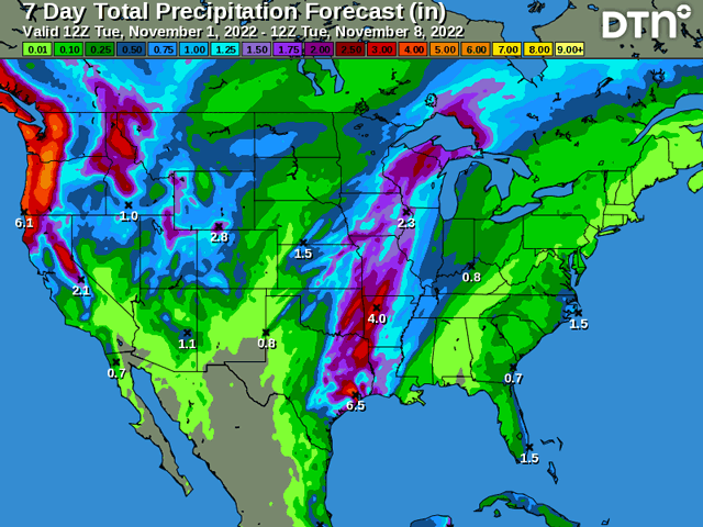
The upper-air pattern has become very active over the last couple weeks. This has led to increased precipitation for the middle of the country that had gone dry over the summer and the first half of fall. However, it has left the western Plains fairly dry.
West Texas has been able to receive some of the showers, but western Kansas, Colorado, western Nebraska, Wyoming, and South Dakota have all been very dry during this period of active weather. Systems have moved through these areas with increased winds and wildfire risks, but not with precipitation. For the most part, the fronts moved through either with not enough vertical lift to produce thick clouds and rain, or not enough available moisture, or a combination of the two. Instead, the heavier precipitation has started as the fronts moved farther southeast through the Plains and into the Midwest.
To get the precipitation to fall in the western Plains, a good mechanism is to get big systems to develop in Texas and move northeast to the western Great Lakes. These types of storms will wrap around moisture syphoned off the Gulf of Mexico and spill it westward toward the Rocky Mountains. It is not the only way to get widespread rainfall in the western Plains, but it is a good one.
P[L1] D[0x0] M[300x250] OOP[F] ADUNIT[] T[]
One such system is possible later this week. A front will move into the Plains Nov. 3-4 and a low-pressure center is forecast to form along the front around west Texas on Friday night. The system will then push northeast toward Hudson Bay on Saturday and Sunday. The storm will be able to pull in moisture off the Gulf of Mexico, but there is doubt into how wrapped up this system will get. Models are struggling with this potential. If this system does wrap up a bit more, we should see more precipitation across those western Plains areas that have been missing out. If it is less wrapped, we should see the rain falling in areas that have recently been getting the good rainfall -- from eastern Texas to the central Great Lakes.
These eastern areas are also looking for more rain. Drought has eased over the last seven to ten days, but it has not been eliminated. Rainfall deficits over the last two months are still in the two- to six-inch range in a lot of these areas. Winter wheat grows in these spots as well and more moisture is needed for good establishment.
The USDA NASS Crop Progress Report on Oct. 31 noted just 28% of the winter wheat crop is in good or excellent condition on a national level. But the areas in the middle of the country are much lower on average. In the Plains, these conditions are between 0% in Texas to 29% in South Dakota. The largest production state, Kansas, is sitting at 24%; 42% of the crop in this state is either poor or very poor. These are among the lowest conditions at this time of year in the last 20 years -- not a good start for the 2023 wheat season. If this system does not produce good precipitation later this week, there does not look like another good chance for a while yet. The American GFS model has potential at the end of its run in mid-November, but that is a longer-range forecast that is hard to trust two weeks out.
The active pattern will continue beyond this weekend, though. A trough in the West will continue to send pieces of energy through the country next week as well. However, forecasts point to a more northern track, which leaves the Central and Southern Plains relatively dry.
John Baranick can be reached at John.Baranick@dtn.com
**
Join me for the 2022 DTN Virtual Ag Summit December 12-13 where I will talk about the winter weather outlook in more detail and what that means for agriculture going into the 2023 growing season. All of the information you expect from DTN, from the comfort of your home or office. For details on the agenda and how to register, visit www.dtn.com/agsummit
(c) Copyright 2022 DTN, LLC. All rights reserved.

Comments
To comment, please Log In or Join our Community .