

South America Calling
La Nina Continues to Affect South American Corn and Soybeans

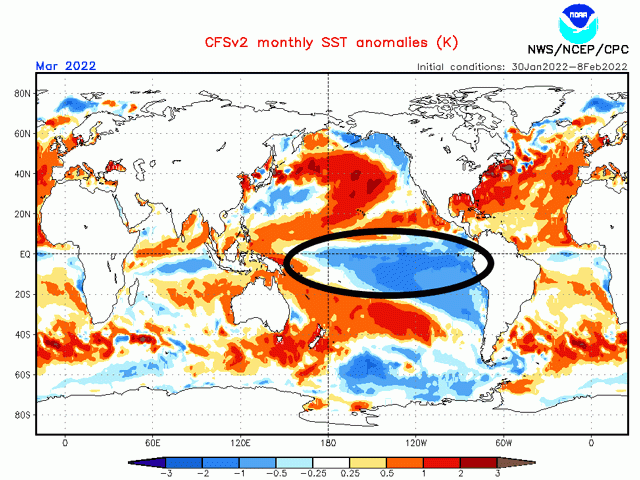
The influence of La Nina on the weather conditions in South America this crop season cannot be overstated. But this recent La Nina event has not been a particularly strong one.
As far as La Nina conditions go, its peak of minus 1.1 degrees Celsius (minus 1.9 degrees Fahrenheit) from the climatological average in December rates it as just a moderate La Nina, and milder than the La Nina last winter. A reading of minus 1.5 degrees C (minus 2.7 degrees F) or lower would signify a strong La Nina. Last season's La Nina event peaked in October and November 2020 at a minus 1.4 degrees C below average.
It is amazing to think that the temperature of the water changing by just a degree or two from where they normally are would have such a dramatic impact on worldwide weather patterns. Those types of changes regularly happen on an hourly basis over land. But the vastness of the area that is affected is quite incredible. The area that is currently below normal in the central and southern Pacific Ocean is on par with or slightly larger than the total area of South America. A disruption that large is bound to create some ripples in the weather patterns across the world, especially the adjacent areas from Australia through Asia, and North and South America, quite a vast area of impact.
Conditions across South America during La Nina events favor increased precipitation across northern Brazil and decreased rainfall amounts in Argentina and southern Brazil. That has certainly been the case this year as Argentina and southern Brazil have gone deep into drought. For southern Brazil, the drought is an extension of the one from last year. In Argentina, the drought last year was not as expansive or dramatic. The reason could be that last season's peak occurred in October and November, a dry period across the majority of the continent but before a large portion of the corn and soybeans were planted in Argentina. But this year's La Nina did not peak until a month later in December to early January. This coincides with much more of the planting and early development period of late-planted corn and soybeans across the country, covering much more of the total crop during more of their development cycles.
And the effects are not going away any time soon. Forecasts from most models have fairly stagnant cooler anomalies through March before temperatures start to rise and head closer to a neutral state. The effect would likely keep a drier Argentina and southern Brazil intact through that time. Indeed, long-range forecasts from both the European and American models continues this trend through the end of March. These next six to eight weeks are critical in Argentina as early development and reproductive stages are going to occur for the vast majority of the crop or will have completed, setting in the potential damages even if rains increase in April or May.
P[L1] D[0x0] M[300x250] OOP[F] ADUNIT[] T[]
In southern Brazil, the damage has already been done to full-season corn and first-crop soybeans and recent updates to all production estimates both private and public have reflected that in soybeans.
With a large portion of the corn crop coming from the second-season (safrinha) crop, corn estimates have been a little more tamer toward being slashed. Safrinha corn in the state of Parana is only 19% planted thus far and the crop is mostly rated as good at 85% due to some recent rainfall. Of that already planted, 54% is still germinating while the other 46% is developing. There is still quite a lot of time for this crop to go before significant damage is done to it.
But the outlook through the end of March is not encouraging. I will say that as the cold fronts that move through Argentina every so often with limited rainfall travel farther north into Brazil, the likelihood for heavier showers increases. That could offset some of the dry bias in the models. But overall, the outlook is still on the lower end of the spectrum of optimism for the safrinha corn crop in southern Brazil.
Meanwhile, showers are having a hard time letting up in central and northern Brazil. There were a couple of weeks in late January where showers became more isolated and were easy enough to work around for those producers in Mato Grosso to get into the fields, harvest their soybeans, and plant their safrinha corn.
The state of Mato Grosso, which accounts for more than 40% of the safrinha corn production in Brazil, has already completed nearly half of their soybean harvest, as well as more than 40% of its safrinha corn planting. Both numbers are well ahead of the normal pace for this point in the season, owing to a fantastic start to the soybean season in late September and early October.
But the return of nearly constant rainfall is making that more difficult. I would anticipate that the rains that continue during the next couple of weeks will have at least some slowing effect on the continued progress.
If producers are forced to wait further into February or possibly March, they risk their safrinha corn going into the dry season during pollination and grain-fill. The end of the wet season comes sooner during La Nina years on average. Last year was a dramatic example where the rains shut down nearly a month early. The effect is not a guaranteed feature, however, so the risks may not materialize. And of course, the soil column is pretty full of water from the rains that have bombarded the region since November.
On another note, I will be at the Louisville National Farm Machinery Show next week. There, I will discuss the weather outlook for the remainder of the 2021-2022 season for Brazil and Argentina. If you are in town for the show, stop by the DTN booth and say hello! I would love to meet with you and learn about your farming operations.
To find more international weather conditions and your local forecast from DTN, head over to https://www.dtnpf.com/…
John Baranick can be reached at john.baranick@dtn.com
(c) Copyright 2022 DTN, LLC. All rights reserved.
Comments
To comment, please Log In or Join our Community .