
Market Matters Blog
Low Water in Mississippi River Causing Saltwater Breach in Louisiana

The current National Weather Service Mississippi River forecast indicates the Mississippi River will fall to historic lows over the next several weeks. As a result, salt water from the Gulf of Mexico is heading upstream and Plaquemines Parish has been affected by this issue since June. Drought conditions have only gotten worse since then, which means additional communities along the Mississippi River in Louisiana could be impacted, noted a press release from Louisianna Governor John Bel Edwards.
"Unfortunately, without any relief from the dry weather we are starting to see the saltwater intrusion creep further up the river despite efforts to mitigate the problems by the Army Corps of Engineers," said Edwards. "Our team at Governor's Office of Homeland Security and Emergency Preparedness (GOHSEP) is working with all of our local, state and federal partners to determine what additional support will be needed and what steps can be taken to protect water systems and water intake points. Most importantly, this is not a time to panic or listen to misinformation. We have been through this situation before in 1988, and we are monitoring this situation very closely and applying the lessons learned. It is extremely important for the public to stay informed and only rely on credible sources for updates during this event."
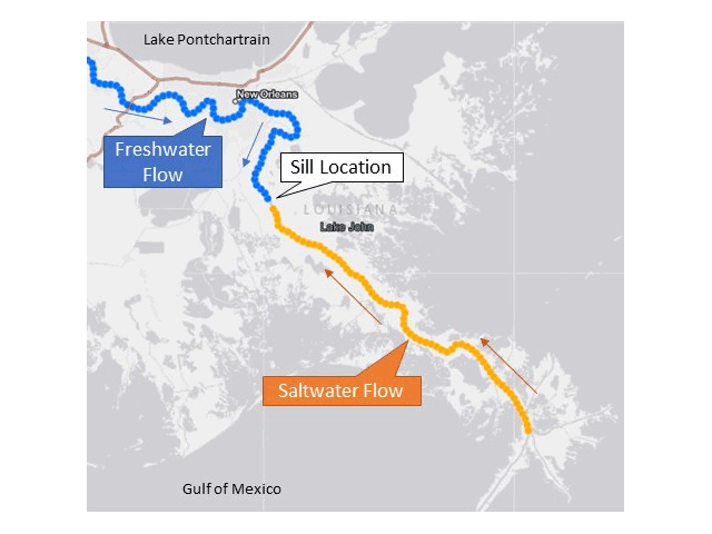
USACE did construct an underwater barrier sill in July 2023 to create an artificial basin to help delay any intrusion of saltwater. Just recently, the upriver intrusion of saltwater from the Gulf overtopped the sill's existing elevation.
"The Corps of Engineers will pursue every effort within our authority to support the state and local response to the extreme low-water conditions," said Col. Cullen Jones, USACE New Orleans District commander in the news release. "Next week (week of Sept. 25), we will begin augmenting the existing underwater sill to further delay the upriver saltwater progress by an estimated 10 to 15 days. Concurrently, we are establishing the capability for barging freshwater to municipal water treatment facilities to support local production of safe drinking water.
"We just executed the contract to get the initial capacity for 15 million gallons on site next week, and then we are rapidly moving through the Corps of Engineers to obtain more," said Jones. "The barges will range in size from 100,000 gallons to 1 million gallons." He noted he will also ask FEMA to issue a federal emergency declaration, which he said could help in getting federal funds to help pay for the response, according to NOLA.com.
Jones added the barges would gather water upriver and deliver it to water treatment plants that will have installed reservoir barges. The fresher water will be mixed with the water already being removed from the river to lower the salt content to acceptable levels. The barges, of course, must be cleaned to standards allowing water transport.
P[L1] D[0x0] M[300x250] OOP[F] ADUNIT[] T[]
The Corps said the increase in the sill height could delay the saltwater intrusion by 10 to 15 days, but without significant rainfall in the Ohio River Valley, there's a chance the salt water will once again top the sill.
LINKS
Louisiana's governor sent a letter to President Biden asking for an emergency declaration. Read it here: https://gov.louisiana.gov/…
The National Weather Service Advanced Hydrologic Prediction Service estimates the Mississippi River at Memphis will hit a new low-water record of -11.2 feet on Wednesday. See more at the Mississippi River hydrograph Memphis site: https://water.weather.gov/…
Mississippi River at New Orleans hydrograph: https://water.weather.gov/…
Link to USACE tracking the saltwater wedge: https://www.mvn.usace.army.mil/…
Press release from Governor of Louisianna: https://gov.louisiana.gov/…
Saltwater intrusion facts: https://gohsep.la.gov/…
Ohio River at Cairo hydrograph: https://water.weather.gov/…
Mississippi River hydrograph Baton Rouge: https://water.weather.gov/…
Mary Kennedy can be reached at Mary.Kennedy@dtn.com
Follow her on X, formerly Twitter, @MaryCKenn
(c) Copyright 2023 DTN, LLC. All rights reserved.
Comments
To comment, please Log In or Join our Community .