

Ag Weather Forum
A Sign of El Nino Through Mid-December
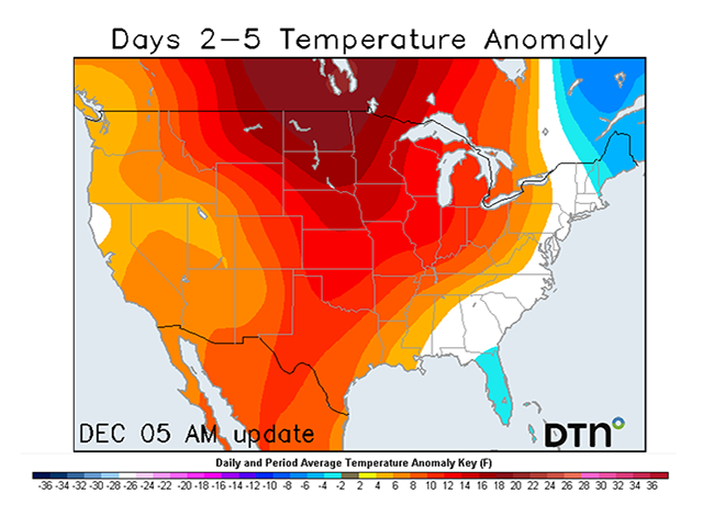
Temperature readings will likely approach 16 to 20 degrees Fahrenheit above normal across the Northern Plains and Upper Midwest through Wednesday and Thursday this week. These won't be the only regions experiencing above-normal temperatures for the second half of this week though.
The warm airmass will likely extend throughout much of the western and south-central United States as well, before shifting east late this week. Above-normal temperatures like this are not completely unheard of for an El Nino winter and warmer conditions may persist through the middle of December.
A weak clipper system moved through the Dakotas and Midwest Monday and Tuesday, which provided some light rain and snow accumulations from North Dakota through Indiana.
P[L1] D[0x0] M[300x250] OOP[F] ADUNIT[] T[]
Behind this clipper, a large upper-level ridge from the West will shift into the Central U.S. Wednesday. This ridge is what will lead to largely dry conditions and above-normal temperatures. By Thursday, afternoon high temperatures will approach the upper 50s to low 60s in southern South Dakota. Temperature will be even warmer farther south. High temperatures will be in the upper 60s to low 70s across western Texas, southwest Kansas, and western Oklahoma.
The weather will turn active this weekend as a low-pressure system and its cold front will sweep across the center of the country which could lead to scattered rain and snow showers from the Central and Southern Plains into the Midwest and Delta. Weather models are still showing some disagreements regarding how exactly this system will evolve, so there will be more to come on this storm system later this week as we await models to show more agreement.
Luckily much of the Central U.S. will not have to brace for plummeting temperatures behind this weekend's cold front. Above-normal temperatures will hold on across the Northern Plains and Upper Midwest while temperatures will be closer to normal for the Central Plains.
Portions of the Southern Plains and Southern Delta may dip 2-6 degrees F below normal Sunday into Monday. Looking ahead throughout the rest of next week, above-normal temperatures in northern areas will likely remain intact but spread into the South-Central U.S. as well.
Beyond next week, long-range model guidance is hinting at above-normal temperatures lingering across the Midwest, Plains, and Delta through at least Dec. 20.
The above-normal temperatures this week into next week isn't unheard of for December during a strong El Nino. In the winter months of December through February during strong El Ninos, the North-Central U.S. has had a record of experiencing temperatures that are above normal. For example, during December 1997 when a strong El Nino was in progress, the Northern Plains averaged 5-15 degrees F above normal.
With temperatures over the next few weeks showing influences from the strong El Nino we are currently experiencing, it is possible that January and February could show similar temperature trends. Above-normal temperatures are favored across the North-Central U.S., however it is important to remember that El Nino is a seasonal climate factor and that the day-to-day weather may vary from the seasonal forecast. Producers across the center of the country will have the opportunity to enjoy rather mild conditions through at least next week but shots of cold air remain a risk throughout the rest of this winter.
To find more weather conditions and your local forecast from DTN, head over to https://www.dtnpf.com/….
Teresa Wells can be reached at teresa.deutchman@dtn.com
(c) Copyright 2023 DTN, LLC. All rights reserved.

Comments
To comment, please Log In or Join our Community .