


Ag Weather Forum
Strong Cold Front Bringing Temperatures Back to Reality for Thanksgiving Week
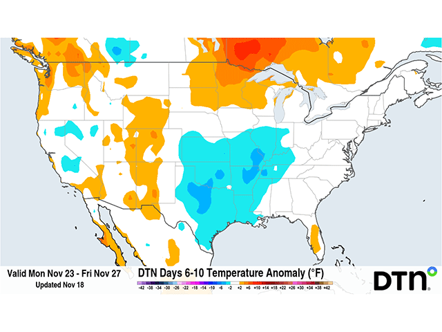
Extremely warm temperatures have again developed east of the Rockies this week. Anomalies are somewhere in the 20-30 degrees Fahrenheit above normal range across large areas of the Plains and Upper Midwest to end this week. A strong cold front will push through the country this weekend, which will send much cooler readings across the country for the week of Thanksgiving. It may not be exceedingly cold, but a harsh step downward for many areas.
Outside of a cooler weekend and early part of this current week, temperatures this fall have been exceedingly warm. For those of us across the northern tier of the country, myself included, it can be difficult to realize just how warm it has been. I mentioned some of the rankings in an article last week here: https://www.dtnpf.com/…. Some other interesting tidbits I have been seeing around my neck of the woods for Minneapolis, Minnesota:
1 -- Average highs are moving down into the upper 30s F. The actual highs have been in the upper 50s F this week. Only two days in November have fallen below the normal high, and only by 3-4 degrees F on Nov. 12-13.
P[L1] D[0x0] M[300x250] OOP[F] ADUNIT[] T[]
2 -- Overnight lows are in the mid-20s F on average for mid-November. Only five days have fallen below the freezing mark this fall, all of them in November. The average first frost date is about Oct. 11. The first occurred nearly a month later on Nov. 6.
3 -- This could be the latest first measurable snowfall on record. There has yet to be a snowflake falling from the sky. The latest that Minneapolis saw a trace of snow was Nov. 21. The latest for the first measurable 0.1 inch of snow is Dec. 3. The averages for both are Oct. 15 and Nov. 4, respectively.
Similar findings have been noted across large portions of the country, especially in the Upper Midwest. The only significant snowfalls have occurred in Montana, South Dakota, along portions of the Great Lakes due to lake-effect snow, and in the higher elevations of the West and Northeast. Snowfall has been tough to come by so far this fall, when it should be becoming frequent. Daily high temperatures records may not be falling at an exceeding pace, but the overall warmth has led to a lot of monthly and seasonal records.
So, getting any break from the extreme warmth is noteworthy, and a cold front will be doing just that this weekend. The system responsible is currently in the West on Nov. 19 and will move through the Northern Plains on Friday, Nov. 20 and through Ontario and Quebec on Saturday, Nov. 21. Scattered showers and some limited areas of snow will likely fall due to that system, but it will be the system's cold front that will be the most noteworthy. As the front swings through this weekend, a significant drop of 20-25 degrees is expected behind it. For areas across the north, this will bring through a couple of days of near-to-slightly-below normal air. Going from extreme warmth to near normal will feel like a big jump, but seasonable temperatures for a couple of days aren't much to complain about. Especially as temperatures rise by the middle of next week in the Northern Plains and spread eastward through northern areas the rest of the week. Thanksgiving is likely to find temperatures near or slightly above normal from Nebraska to New York and points northward. Western states should find similar warm anomalies.
But for southern areas of the country, and parts of the East, the effect will be a little more noticeable and may last a little longer. With warm anomalies only 10-15 degrees above normal ahead of this cold front, a drop of 20 degrees would put temperatures 5-10 degrees below normal. Peak anomalies of 10-15 degrees below normal may initially move through the Mid-Atlantic before moderating midweek. And with the overall pattern favoring a continuation of weak systems, cloud cover, and precipitation, anomalies may stay in that 5- to 10-degree below normal range across the southern tier through much of next week. However, it would still mean daytime highs largely in the 50s and 60s F for most areas and overnight lows in the 30s and 40s F. Though cool, it is not an arctic blast that many still hang onto on social media.
This pattern is very typical during El Nino, such as the record-strong one we are currently experiencing. Temperatures ahead of systems become extremely warm and fall near to slightly below normal behind them. This is a warm overall pattern but is usually a fairly active one as well. While we will see systems moving through next week, they are likely to be disorganized. One disturbance looks like it will move through the Central and Eastern U.S. in the Tuesday-Wednesday timeframe, Nov. 24-25. Another storm is being indicated later in the week, during the Friday-Sunday timeframe, Nov. 27-29. Uncertainty exists with both systems, but they are likely to be weak without any real access to changing air masses. Even with the cooler air around, they are also unlikely to produce much, if any snowfall, extending some records for the Upper Midwest deeper toward or into December. As we have seen in the extended forecast for the last couple of weeks, changes in the models can be significantly large, so stay tuned for further updates.
To stay up to date with weather conditions and your local forecast for free from DTN, head over to https://www.dtnpf.com/…
John Baranick can be reached at john.baranick@dtn.com
(c) Copyright 2026 DTN, LLC. All rights reserved.