



Ag Weather Forum
Hiccup This Weekend to Otherwise Record Warm Fall Pattern
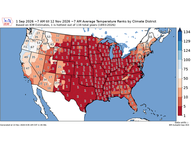
It's getting cold this weekend from the eastern Plains to the East Coast. Temperatures are falling below normal, and in some cases will be 10--15 degrees below the average for the date. For a lot of these areas, it will feel extra chilly because of how warm it has been this fall season so far.
In fact, for most of the climate districts east of the Rockies, this fall ranks in the top five of warmest fall seasons so far, and for most of these districts, it's the warmest over the last 134 years dating back to 1893. Data from the Iowa Environmental Mesonet pegs the period of Sept. 1 through Nov. 12 as the warmest for all climate districts in seven states (Missouri, Arkansas, Illinois, Indiana, Ohio, Kentucky, Tennessee), and either the first or second warmest in five other states (Kansas, Oklahoma, Texas, Louisiana, and Mississippi). Only some small areas of the far Northern Plains along the Canadian border (where rankings are still in the top 12), around Florida (where the rankings are still in the top 10), and from Pennsylvania and the Delmarva Peninsula up through Maine sit outside of a top--five ranking. Western states have generally been above normal as well, and many of these have a ranking in the top 20, though some climate districts in the Pacific Northwest have seen below-normal readings this season.
P[L1] D[0x0] M[300x250] OOP[F] ADUNIT[] T[]
For most areas in the South and Southeast, frosts will be common this weekend, getting as far south as Oklahoma and perhaps even to the Gulf of America Coast from Mississippi to northern Florida. The National Weather Service has frost advisories and freeze warnings from central Mississippi to the Carolina coast for Saturday morning. It may have to extend those advisories farther south toward the coast later Friday. But in general, this is the time of year for these areas to see their first frost. For a few locations that didn't see it this past weekend, it will be generally on time or a little later than average. But for the Gulf Coast, this may be a bit on the early side.
Getting cold air to move into the U.S., and especially the South, has been a tough task so far this season thanks to the building El Nino -- a pattern that favors a source of air from the milder Pacific Ocean instead of getting cold air down from northern Canada or the Arctic. You can read more about that here: https://www.dtnpf.com/…. The air from this event is not sourced from the Arctic either. Instead, it is from eastern Canada, where temperatures are cool, but not excessively cold. However, after enduring temperatures about 10 degrees above normal earlier this week, readings of 10-15 degrees below normal will feel like quite a shock.
The cold air will last through the weekend, and below--normal readings will still exist for those in the Southeast for early next week. But temperatures will be rising again and some areas of the Upper Midwest could break some record high temperatures again toward the middle of next week, around Nov. 17--19. That would only cause the records to widen the gap, even after this brief pause in the otherwise extremely warm fall season.
To stay up to date with weather conditions and your local forecast for free from DTN, head over to https://www.dtnpf.com/…
John Baranick can be reached at john.baranick@dtn.com
(c) Copyright 2026 DTN, LLC. All rights reserved.