

South America Calling
Flip-Flopping Brazil Forecast Leads to More Favorable Conditions for Early Soybean Development
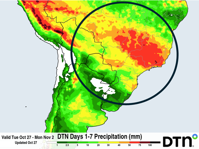
Another week of changing weather is settling into Brazil. What has been a fairly dry season in central Brazil contrasts with a very wet southern Brazil. There has been some back-and-forth to this pattern over the last month, which continues again this week.
It has so far been an erratic season in Brazil. The world's largest producer of soybeans counts on a very timely start to its wet season at the end of September to increase soil moisture across central Brazil in October, the primary planting month. From there, frequent rainfall helps to provide adequate moisture to poor soil textures and keep growth going during extremely hot periods of near or over 40 degrees Celsius (around 100 degrees Fahrenheit). Across southern Brazil, frequent frontal passages are needed to bring in moisture in a relatively milder region of the country that can still experience heat waves, and where soil texture can still be poor.
P[L1] D[0x0] M[300x250] OOP[F] ADUNIT[] T[]
This season so far has featured the frequent fronts, which have pushed north through southern Brazil or stalled, with almost daily rainfall over the last couple of months, something that is more indicative of regions across central Brazil. In contrast, central Brazil has seen very little of monsoonal pop-up showers and thunderstorms that typify the wet season rainfall. This has in large part come because of the strongest El Nino event on record. A drier central Brazil and wetter southern Brazil is very typical during this pattern, which has played out as forecast so far.
Producers have been a touch behind in their planting progress across the south because of the excessive rain. Some flooding has occurred and Conab, the USDA equivalent in Brazil, has been mentioning that producers are finding some time between showers to continue planting, but are a bit concerned about diseases and weed pressure because of all the rain. The sporadic rain farther north is bringing some concern about dryness being an issue, but giving very good windows for planting. Mato Grosso, Brazil's largest production state, is well ahead of the normal planting pace and setting up for a good season as long as the rain returns. They are over 75% completed with soybean planting, compared to the five-year average of 64%, according to the Mato Grosso Institute of Agricultural Economics (IMEA).
This week, it appears that central Brazil will get its opportunity for rain. A system that went through southern Brazil this weekend has pushed a front into central Brazil earlier this week. That front has stalled and is forecast to bring about widespread rainfall throughout the week. This supplements the decreased rainfall from the monsoon showers. While the rainfall appears to be heavy at first glance, forecast amounts over the next 7 days are around 30-60 millimeters (about 1.2-2.4 inches). That is generally a normal week's worth of rain in the region. For some areas that may be a bit higher, but for others, it may also be a bit lower. In Mato Grosso, those forecast amounts are roughly 80% of normal rainfall for this point in October. The rain is only keeping up with the normal pace and not building excess moisture for the time being.
With the front stalled across central Brazil, southern Brazil is getting in on some drier weather. Rio Grande do Sul, on the far southern end of the country, is forecast to be nearly completely dry over the next 7 days while states like Parana and Mato Grosso do Sul are only forecast to see occasional passing showers adding up to less than 25 millimeters (1 inch). That should give these areas more opportunity for recovery in their soils and for fieldwork to accelerate, including controlling for weeds and disease.
To find more international weather conditions and your local forecast from DTN, visit https://www.dtnpf.com/….
John Baranick can be reached at john.baranick@dtn.com
(c) Copyright 2026 DTN, LLC. All rights reserved.