


South America Calling Blog
Forecast Improving for Brazil, But Only Temporarily
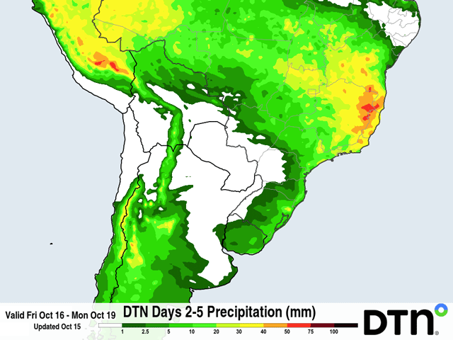
The wet season rainfall in central Brazil can be thought of generally as starting on time. However, the frequency and coverage of rainfall has been sparse so far in October.
Prior to showers and thunderstorms moving in on Oct. 14, rainfall had generally been less than 25 millimeters (about 1 inch) from Mato Grosso to Minas Gerais and points northward. At the same time, rainfall across southern states has exceeded 100 millimeters (4 inches) and has led to concerns about soaked fields and disease pressure.
The conditions are changing over the next couple of days, but it may be brief as another system moves into southern Brazil later next week.
Producers in central Brazil rely on good rainfall in October after several months of nearly completely dry weather to load up soils with moisture for their first crop of soybeans. When rains do not fall, temperatures rise up to near 40 degrees Celsius (104 degrees Fahrenheit), causing significant stress to young soybean plants.
P[L1] D[0x0] M[300x250] OOP[F] ADUNIT[] T[]
Producers sometimes wait for good soil moisture and a favorable short-term forecast before planting, though this year they are well ahead of the average pace. A report from the Mato Grosso Institute of Agricultural Economics (IMEA) indicates that soybean planting was 33% complete as of Oct. 9, about 8 percentage points ahead of the average planting pace in the state. This is a time of rapid planting, which usually finishes up in the first week of November. Rainfall now is critical for good germination, a problem that occurred with inadequate rainfall last October. Though soybeans are famous for being able to endure harsh conditions early in the season, a lack of rainfall could cause some areas the need to replant, putting their second-crop (safrinha) corn at risk as well.
But rainfall has shifted north from southern Brazil this week, getting more widespread rain into the region from a front slowly passing through. Rainfall amounts through the coming weekend are forecast to be in the 25- to 50-millimeter (1- to 2-inch) range but would still be below normal over the time period.
After the front fizzles out this week, rainfall next week is forecast to be scant again, like we have seen so far in October. Slow-moving fronts are not the main source of rainfall in central Brazil and a reduced frequency of precipitation due to El Nino seems to be occurring when fronts are not passing through. That will remain a hindrance on rainfall production in the region going into 2027 as this season's El Nino is already the strongest on record in the Pacific.
In contrast, rainfall across southern Brazil has been not only frequent, but intense. Frequent systems have led to stalled fronts in the region for the last couple of months, with a general 50-100 millimeters of rain each week, something that is more common for central Brazil instead of southern states.
With rain spreading north into central Brazil, the skies are forecast to clear into next week, giving a much-needed break to producers still trying to sow seeds, or for plants to get some sunshine and start utilizing all the built-up soil moisture. Government reports from Parana indicate little damage due to the excess rainfall so far, but reduced fieldwork time, slower planting pace, and a concern over pests and diseases, which thrive in the wetter conditions.
The forecast is calling for another system to move in around the middle of next week, Oct. 21, and could bring more rounds of heavy rain, and potential severe weather like wind and hail, to the region.
Forecasts are mixed on how far north this front will get next week, but needless to say producers are hoping that the front comes through and brings more widespread rain. Though rain is rarely a limiting factor for soybean production in central Brazil, the frequency is something to be concerned about, especially if the amounts do not approach average in December, when pods should be getting into their fill stages.
Reduced rainfall over the Southern Hemisphere summer could also have a huge impact on the safrinha corn season next year -- something to closely monitor as well.
To find more international weather conditions and your local forecast from DTN, visit https://www.dtnpf.com/….
John Baranick can be reached at john.baranick@dtn.com
(c) Copyright 2026 DTN, LLC. All rights reserved.