


Ag Weather Forum
Flooding Concerns Continue in Illinois and Indiana After Last Week's Heavy Rain
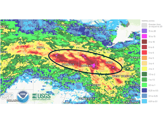
Some incredibly heavy rain fell across portions of the Midwest last week. That has produced flooding, loss of property, and crop damage across a wide area of some prime farmland. Additional rain falling this week, though not nearly as intense, could keep concerns about flooding continuing through the end of August.
A stalled front, and multiple disturbances riding along and north of it, produced daily showers and thunderstorms that continued to build over the same areas time and time again. In some cases, thunderstorms pushed through with severe weather, which included a derecho that produced 70-80 mph wind gusts from eastern Iowa to northern Indiana on Aug. 11. In other cases, thunderstorms seemed to stall out and continue to pour heavy rain onto the same locations for hours at a time.
The results were extremely heavy rainfall from eastern Nebraska through Ohio where 3 to 5 inches was very widespread. Within that zone, many areas picked up more than 6 inches of rain, and extreme amounts nearing and exceeding 10 inches were noted from southeastern Iowa into western Ohio and again in southeastern Ohio. Illinois and Indiana had the most widespread issues with heavy rain, flooding fields, streams and rivers. Many flood advisories for local rivers remain posted. But new flood watches have been posted for Aug. 19 in both states, as more active weather threatens to exceed thresholds on already incredibly saturated ground.
P[L1] D[0x0] M[300x250] OOP[F] ADUNIT[] T[]
The weather pattern continues to be active across the Midwest, but to a different degree through the end of the month. Last week's rainfall was the result of a stalled boundary. The current pattern favors fronts that will sweep across the region. The movement of showers and thunderstorms, and their scattered nature, should lead to a reduced likelihood of heavy rainfall amounts over half an inch, at least in how widespread it would be.
But heavier amounts will still be possible. A front that moves through the Midwest Aug. 19-20 will bring scattered showers, but they will be oriented in such a way that may produce a "train" of storms that hit the same area multiple times, similar to what occurred last week but to a lesser degree.
Still, within training thunderstorms, rainfall amounts tend to be much higher than models project. The National Weather Service remarks that pockets of 2-5 inches of rain will be possible locally due to these training thunderstorms. If they fall over the saturated areas, the return of flooding is likely to occur. Though Illinois and Indiana are the hotbed areas for this potential, flooding may occur in some of the other saturated areas of the region.
This front won't be the only one to move through in the short range, either. Another front is forecast to move through Aug. 21-22 and more showers are in the forecast for next week, though models are less certain about those. Still, the repeated hits to wet areas could be an issue for those with low spots, lack of tiling, and those near rivers and streams.
Though the rainfall amounts may not be overly high, they do not need to be to cause further issues. Those living in saturated areas should closely follow the forecast and conditions to ensure safety.
To stay up to date with weather conditions and your local forecast for free from DTN, head over to https://www.dtnpf.com/…
John Baranick can be reached at john.baranick@dtn.com
(c) Copyright 2026 DTN, LLC. All rights reserved.