



Ag Weather Forum
Tuesday's Severe Thunderstorms Wreak Havoc in the Midwest, Threat Continues Wednesday
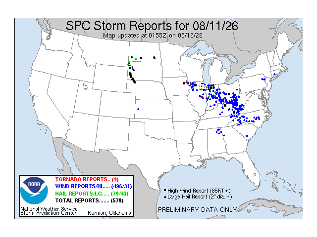
Skies darkened across the Midwest on Tuesday as severe thunderstorms targeted the cities of Chicago, Indianapolis and Cincinnati. Across Illinois, Indiana, Ohio, and Kentucky, over 1 million people were without power as of Tuesday evening with clusters of strong storms still ongoing across the Ohio Valley. While Tuesday's storms left many cleaning up damage from strong winds, Wednesday could be another active day for thunderstorms and heavy rain across the Ohio Valley.
POTENTIAL DERECHO ON TUESDAY
During the very early morning hours of Tuesday, scattered thunderstorms started forming across northern Iowa. By dawn, a strong cluster of thunderstorms had organized across eastern Iowa, and it was tracking east into northern Illinois. Observed wind gusts near 80-85 mph were being reported in northeast Iowa as it moved through. Around 11 a.m. CDT, a strong line of thunderstorms struck the Chicago metro, and it produced wind gusts near 70-80 mph. Building damage and uprooted trees were reported across the Chicago metro. The highest reported gust was near Sugar Grove, Illinois, where a home weather station reported a 97-mph wind gust.
While storms were ongoing across northeast Illinois, severe storms started forming in northern Indiana. Baseball-sized hail, or hail near 2.75 to 3 inches in diameter, hit northern Indiana. A large cluster of showers and thunderstorms extended from northeast Illinois into southwest Michigan, central Indiana, and western Ohio by early Tuesday afternoon. Around 2 p.m. EDT, a line of strong thunderstorms extended from Indianapolis to Columbus, Ohio.
P[L1] D[0x0] M[300x250] OOP[F] ADUNIT[] T[]
Eventually, the line of storms in central Indiana and central Ohio shifted south, affecting Cincinnati and eastern Kentucky later Tuesday afternoon. Behind this line of storms, additional severe storms redeveloped across central Illinois and central Indiana. A tornado was reported near Seymour, Illinois, during the mid-afternoon hours on Tuesday, but the exact strength of the tornado is unknown as of Tuesday evening as the National Weather Service will need to assess damage across the area.
With wind damage stretching from northeast Iowa to eastern Kentucky and southern Ohio, there is a possibility that this storm system gets classified as a derecho. Derechos are classified as long-lived thunderstorms that produce widespread wind damage, and they can sometimes lead to straight-line wind damage. Typically, the swath of wind damage needs to extend more than 240 miles and include wind gusts of at least 58 mph. To read more about derechos and how they form, visit the Louisville, Kentucky, weather forecast office's website here: https://www.weather.gov/….
THUNDERSTORM THREAT CONTINUES WEDNESDAY
On Wednesday morning, a cluster of strong to severe thunderstorms in east-central Iowa will move southeast into northern and central Illinois. Throughout the afternoon, this line of thunderstorms could continue to drift southeast, affecting central Indiana and western Ohio with damaging wind gusts over 60 mph, large hail and a few isolated tornadoes. By Wednesday evening, thunderstorms could extend across southern Indiana, southern Ohio and northern Kentucky before diminishing late in the evening. Wednesday's storms could also have the potential to be classified as a derecho, but it will depend on the strength of the wind gusts and how far the line of storms travels.
In addition to the risk of widespread, severe weather on Wednesday, heavy rainfall and flooding will also be risks across the Ohio Valley, especially for places that saw heavy rain on Tuesday. Some of the heaviest rain on Tuesday targeted Indiana, Ohio, Kentucky and West Virginia. Portions of southeast Ohio saw nearly 4-6 inches of rain within a span of 24 hours, prompting the National Weather Service to issue Flood Warnings for some counties as rivers and large creeks could exceed their banks.
From Wednesday morning into Wednesday night, rainfall totals could approach 0.5-1 inch across much of central Indiana, southern Ohio, western West Virginia and eastern Kentucky. Isolated higher totals exceeding 2-3 inches are possible as well, especially for places that get tagged with multiple rounds of storms throughout Wednesday.
A stationary front is one of the main culprits for these clusters of storms forming in the Ohio Valley this week. However, it takes more than just a stationary front to produce severe storms. A warm, humid airmass is also contributing to a ripe environment for severe weather. Farms across Illinois, Indiana, Ohio and Kentucky will need to be vigilant again on Wednesday for more damaging winds even as cleanup continues from Tuesday's storms.
To find more weather conditions and your local forecast from DTN, head over to https://www.dtnpf.com/….
Teresa Wells can be reached at teresa.wells@dtn.com
(c) Copyright 2026 DTN, LLC. All rights reserved.