



Ag Weather Forum
Caveats to an Otherwise Favorable Corn Belt Forecast
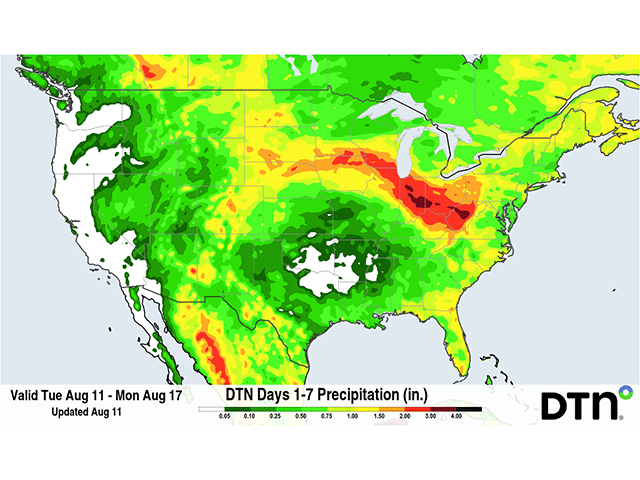
Early August weather in the Corn Belt has been fairly good so far. And the weather pattern that is shaping up for the rest of this week, and possibly the rest of August, is likely to continue the narrative of good weather. However, there are some caveats involved with this forecast that may not be so favorable for some southern areas of the Corn Belt and may have sneaky issues for other areas as well.
Daily chances for clusters of showers and thunderstorms are forecast across the vast majority of the Corn Belt through at least Aug. 16. The weather pattern features an upper-level trough across Hudson Bay and a hot and humid upper-level ridge across the Southern U.S. The trough will provide the disturbances and energy needed to kick off thunderstorms and the ridge will provide the fuel necessary to produce frequent bouts of growing thunderstorm clusters that follow the edge of the ridge.
This creates a situation of nearly continuous rainfall in some portion of the Corn Belt through the weekend and should result in some areas of heavy rain and severe weather. We have already seen some severe weather this week as thunderstorms produced strong wind gusts in the southern Great Lakes on Sunday, and across the eastern Corn Belt into the Mid-Atlantic on Monday. And just this morning, early Tuesday, Aug. 11, there are more clusters moving through the Midwest that are being watched and warned for severe wind gusts.
This so-called "ring of fire" type of scenario was noted before in June when areas of heavy rain went across the Corn Belt and led to decreased drought coverage across much of the region. It's a scenario that is rather frequent during a building El Nino, a situation we currently find ourselves well into as this year's event could be the strongest on record. The rainfall amounts being produced by models through Sunday are quite impressive with widespread areas of more than an inch of rain across the vast majority of the Corn Belt, and some areas in Indiana, Ohio, and Kentucky seeing more than 2 inches.
With multiple rounds coming through, there will be some areas that significantly exceed these totals, which may lead to flooding. Even so, this is the kind of widespread rainfall that filling corn and soybeans in the region needs after a rather dry July.
P[L1] D[0x0] M[300x250] OOP[F] ADUNIT[] T[]
But this rainfall comes with a few caveats. The first has to do with the models themselves. Though there is ample opportunity to produce showers and thunderstorms, not every disturbance is going to be well-forecast.
A prime example is the missed rainfall in South Dakota on Aug. 10. Models had widespread showers and thunderstorms developing over the state in the late afternoon into the overnight, but they did not materialize to any significant degree. Instead, those storms exploded over Iowa on Tuesday morning and that will alter the forecast going forward.
As these storms hit many of the same areas repeatedly, and follow closely behind other clusters, each day's rainfall will depend on what happened the day before. Even small differences on where storm clusters move and where they drop their own specific outflow boundaries, which can act like miniature cold fronts, can significantly alter where storms develop and where they do not. Models do not do a good job of placing these small features, and that could dramatically alter the narrative if storms are enhanced or suppressed in and out of the Corn Belt. As the days wear on, the models get worse and worse regarding development and placement of storm clusters, which can lead to large errors in the rainfall forecast.
Another caveat is that while the primary zone for thunderstorm development is through the Corn Belt this week, it will not be wide enough to cover the entire Corn Belt. Much of the Dakotas, Minnesota, and Wisconsin will be north of the zone through Aug. 13. A system moving through the region on Aug. 14-15 is forecast to bring through more widespread showers and thunderstorms to these areas, but also comes with a risk of being too widespread when the primary storm mode is clusters of storms instead of a shield of moderate precipitation.
Those clusters tend to concentrate precipitation instead of dispersing it, leaving some areas with heavy rain and others with little to none. These northern areas have been dealing with drought issues of varying degree throughout the year, making the rain that does fall incredibly important. Should showers miss to any significant degree, conditions will become worse for filling corn and soybeans.
South of this primary zone is still some very important farmland. Much of Kansas, Missouri, southern Illinois, and spots of the Delta along the Mid- and Lower Mississippi Valley will not only miss out on much of the precipitation through this weekend, but they will also be incredibly hot. Being underneath the upper-level ridge has already forced daytime highs well into the 90s with areas in Kansas down to Texas dealing with temperatures over the century mark.
Humidity is also incredibly high, leaving overnight lows in dangerous territory for not only plants, but for animals as well. The National Weather Service has posted widespread heat advisories and some heat warnings for these areas for the next several days.
And this pattern is not forecast to change much through at least next week, but possibly the end of August as well. The upper-level ridge looks to remain largely in place. However, the Hudson Bay trough may be more of a feature that comes and goes. Doing so will let the ridge expand northward, sending some extra warmth northward, but also shutting down the frequent bouts of precipitation. As the trough returns to Hudson Bay next week, and as other disturbances move over the ridge, expect the rainfall to return to the Corn Belt. But the details of this forecast matter more than the overall narrative.
If rainfall is not as widespread or frequent as models suggest, there could be some building issues heading into the fall harvest period.
To stay up to date with weather conditions and your local forecast for free from DTN, head over to https://www.dtnpf.com/…
John Baranick can be reached at john.baranick@dtn.com
(c) Copyright 2026 DTN, LLC. All rights reserved.