

Ag Weather Forum
Last Punch From the Polar Vortex Before Return to Warm Winter Weather
Harsh, brutal, dangerous. Pick a word or use your own, the cold that has moved into and through much of North America during the last week has been brutal, and in some cases record-breaking. Only those in the Southwest and the southern tip of the Florida Peninsula have been spared from the arctic cold conditions due to visit from the polar vortex during the last seven days.
The polar vortex describes the jet stream that circumnavigates the polar region. When it is displaced from its normal position, very cold air from the Arctic can be pushed southward into the mid-latitudes.
We will see another burst of strength from the polar vortex later this week and weekend, but then see it quickly leave and be replaced by the type of warmth we had seen in December, or at least close to it.
An arm of the polar vortex has been circling around North America since early last week, but its harsh conditions made their presence known in Western Canada starting Jan. 10 and spread throughout much of the Northwest, Plains, and Midwest since. It took some time, but eventually the polar vortex made its way into the Southeast early this week.
P[L1] D[0x0] M[300x250] OOP[F] ADUNIT[] T[]
Though we have seen a bit of a moderation to the extreme cold over northern areas the last few days, the polar vortex is gearing up for another shot of very cold air. A storm system is moving through the Pacific Northwest Jan. 17 and is producing some very heavy snow. That storm will weaken as it moves into the Plains for Jan. 18, but still have a streak of light snow from Montana and Wyoming through much of the Midwest and Mid-Atlantic through Jan. 19. Some areas around the central Appalachians will get a heavier burst of snow out of it, but for most areas, the snow from the system will be light.
However, that storm will pull another round of very cold air into the U.S. for the end of the week and into the weekend. Temperatures will not be nearly as cold as the first round was, but another burst of below-zero-Fahrenheit lows could reach down as far south as the Ozarks for Saturday, and single digits above zero F could go as far south as northern Oklahoma and Alabama. The coldest air will come where the high-pressure center ends up on Saturday morning, currently forecast over Iowa (where morning lows could approach minus 20 F again), and Sunday morning, centered around eastern Kentucky (where low temperatures may fall close to zero F). High temperatures will only be slightly above normal for the Northern Plains and Upper Midwest during the peak and areas in Tennessee may not break the 20-degree mark on Saturday.
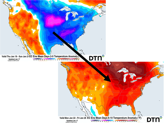
Thankfully, this shot of arctic air will be brief. While the polar vortex rotates another piece of itself, it will quickly find an upper-level ridge developing in the West that will shove it northeast through Canada during the weekend. The ridge will build quite significantly across most of North America but particularly across the eastern half of the continent for next week, dominating the pattern.
The ridge will usher in a quick change to higher temperatures starting on Jan. 21 in the Plains and Jan. 22 farther east. Temperatures may reach up close to 40 degrees F in Minneapolis and possibly up to 50 F in Detroit. Above- and well-above-normal temperatures will be in place for the entire week with the ridge settling in.
At the same time the ridge builds, a trough over the Pacific will squeeze a piece of itself into the Southwest this weekend, become cutoff, and get stuck around northern Mexico and Texas for next week. That should lead to flow from the Gulf of Mexico that will pump in not only heat but moisture.
Rainfall will be common in the Southern Plains and South-Central states for much of next week. The flow should bring showers through a good portion of the Midwest as well. Model forecasts for next week have a general 1.5 to 3 inches of rain from eastern Texas through the Tennessee Valley and the surrounding areas, with another inch or more for large sections of the southeastern Plains, Midwest, and Southeast.
With temperatures being much warmer, much of this will fall as rain, even in parts of the Upper Midwest. Temperatures are likely to be more borderline farther north, which could cause some wintry mix that we will need to monitor, but any addition to the snowpack across the north is unlikely. In fact, with all the warmth, the snow cover should see an overall decline next week, even for those that have seen over 2 feet of the white stuff from last week.
This change to an overall ridge with an undercutting trough across the South is the pattern we were accustomed to experiencing in December and the first week of January, and a typical background feature during El Nino. Though snow cover is far more expansive now than it was back in December, which will put a lid on some of the warmth, a return to mild winter conditions is expected. This pattern likely continues through the last days of January, but there is potential for North America to see another shot of seasonably cooler air in early February. It does not look like the arctic blast we are currently in, but may bring in some break from the warmth. There are other indications of some cold weather moving in during mid-February as well, but all of these are just hints thus far. It will take some consistency in the models to gain any confidence on the potential return to cold weather.
To find more weather conditions and your local forecast from DTN, head over to https://www.dtnpf.com/…
John Baranick can be reached at john.baranick@dtn.com
(c) Copyright 2024 DTN, LLC. All rights reserved.