
Ag Weather Forum
Heat Breaking for Some, Extended for Others Going Into August
An extensive heat ridge has spread across the United States this week with unseasonably hot weather. Already we have seen several days of temperatures nearing or exceeding the 100-degree Fahrenheit mark for the Southwest and Plains. And that will include areas close to the Mississippi River and across the Gulf Coast for the next few days as well.
Extreme heat at this time of year is incredibly stressful for corn and soybeans in their most vulnerable stages of development, during pollination and early grain fill. In addition, it is also stressful for livestock, especially those in open feedlots where winds are light, as well as for humans outside working their farms and ranches. This creates a tough time for large portions of the country's primary agricultural areas. That is especially true when the heat is consistent and extended.
Thankfully, for a large portion of the Corn Belt, this heatwave will be brief. A trough of low pressure moving through southern Canada will send a cold front along the northern edge of the U.S. during the next couple of days. With the trough deepening across eastern Canada this weekend, the front will drag south through the majority of the Corn Belt states, down to Kansas and Tennessee. Temperatures north of the front will be much closer to normal for this time of year, and a couple of days slightly below normal will be possible as well. The break in the heat will be significant.
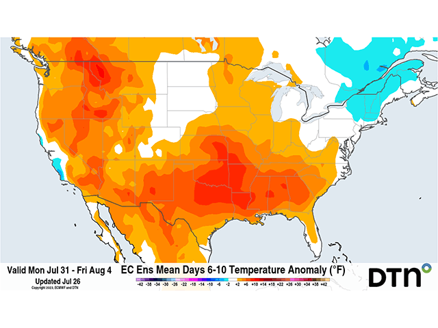
But the trough will not extend far enough south to push the heat ridge completely out of the eastern half of the country. The front is forecast to stall there from the Central Plains to the Tennessee Valley and may even move northward again next week. That will keep the Southern Plains through the Southeast mired in heat, again nearing or exceeding the triple-digit mark through most, if not all, of next week. Western states will also remain under the ridge, keeping temperatures west of the Rockies well-above normal as well.
P[L1] D[0x0] M[300x250] OOP[F] ADUNIT[] T[]
With the heat stress being magnified during the next 10 days or so, and with so little subsoil moisture to rely upon, precipitation will be extremely important. Not only would rainfall help to keep crops thriving longer through the heat, but cloud cover and rain can reduce daytime temperatures significantly, reducing heat stress as well. Though any relief may be temporary, it would certainly be welcome. There is not a spot in the country where rainfall would not be beneficial.
Luckily, the edge of these heat ridges are good areas to produce at least clusters of showers and thunderstorms. We have already seen some of that occurring across the northern tier of the country Tuesday and Wednesday, with clusters of thunderstorms moving from the Dakotas and northern Nebraska through the Upper Midwest and across the Great Lakes. Rainfall amounts nearing an inch and somewhat lower temperatures have been a welcome sight to these areas in drought that have had a tough time finding rainfall lately. As the front sags south, it will be able to tap into the high heat and humidity to its south and create more showers and thunderstorms. Though some severe weather will need to be monitored, widespread rainfall is forecast as the front sinks over the coming days.
With the front largely stalling across the Central Plains to the Tennessee Valley for next week, and the heat dome situated to the south, it would stand to reason that the southern Corn Belt would be on the receiving end of some more beneficial rainfall. Models do not necessarily agree, however. Instead, further disturbances rounding the trough in the Corn Belt are favored with the higher precipitation chances. Arguments could be made to trust either scenario. A storm track farther north would benefit northern areas while stressing southern ones, where heat and a lack of rainfall could be damaging.
Suffice to say, models have not had a good track record beyond Day 7 this summer. While that is not entirely uncommon during the summer season, as thunderstorms make the majority of the rainfall and are hard for models to depict, it should lead to some lower confidence in these models and their output in the extended range.
That leads to the conversation about how the rest of August plays out as well. Longer-range models do give a break to the Southern Plains and the Southeast heat the following week, after Aug. 5, by setting up a stronger eastern trough and western ridge. Such a pattern would favor milder weather farther south, as well as increased rainfall. Later in the month, both the extended version of the American GEFS model, and the European spread the heat ridge back to the east, which also results in below-normal precipitation.
This is a forecast that the DTN long-range forecast team is on the fence about. DTN Long-Range Weather Risk Analyst Nathan Hamblin has reason to believe the opposite may be true. "I'm going out on a limb here, but the tropical forcing element to the forecast is one that would suggest a retrograding trough through the middle of the country instead of a ridge. Such a situation would be a milder and wetter period than models suggest."
He mentioned that this may only be an extension of the early August pattern rather than anything completely new, but would mean more favorable temperatures for most of the U.S. east of the Rockies. The precipitation pattern would be harder to determine, but likely favor the southern Corn Belt to the Gulf Coast, perhaps the High Plains as well. With so much uncertainty in the forecast, it is hard to make a determination how August will turn out and we will continue to be in a wait-and-see mode. It is something we have been accustomed to this season.
To find more weather conditions and your local forecast from DTN, head over to https://www.dtnpf.com/…
John Baranick can be reached at john.baranick@dtn.com
(c) Copyright 2023 DTN, LLC. All rights reserved.