2023 Gulf of Mexico Hypoxia Forecast
Gulf Dead Zone Predicted to be Smaller, But Still Twice the Size of National Goal
Scientists have released their 2023 forecast for the so-called "dead zone" in the Gulf of Mexico -- predicting it will be around 4,100 square miles this summer. That's more than 20% larger than last year, but still smaller than average.
The dead zone is a hypoxic area where low oxygen can kill fish and other marine life. It's caused by excessive nutrient runoff, largely from fertilizer used on farm fields in the Midwest, which ends up in the Mississippi River and flows south to the Gulf.
The National Oceanic and Atmospheric Administration uses models and data from the U.S. Geological Survey to forecast the size of the dead zone each year. Data from river and stream gauges showed that nitrate and phosphorus discharges were below average in the Mississippi River and Atchafalaya River, which splits off in south Louisiana.
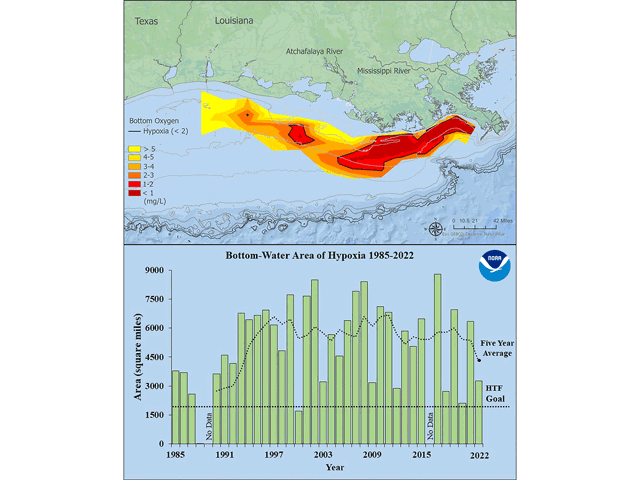
While some see this season's forecast as good news, it is still well above the federal Hypoxia Task Force's goal of shrinking the dead zone to 1,900 square miles or smaller by 2035. The area's five-year average size is 4,280 square miles, more than double that target, and has trended mostly larger over time.
Don Scavia is an emeritus professor at the University of Michigan and leads one of several research teams partnering with the federal government on the annual forecast.
"Lack of a downward trend in the dead zone illustrates that current efforts to reduce those loads have not been effective," Scavia said. "Clearly, the federal and state agencies and Congress continue to prioritize industrial agriculture over water quality."
LOWER RIVER RATES
A NOAA press release said the results were due to lower river flow rates. Despite lots of rain and flooding in the upper Midwest early this spring, discharge in May in the Mississippi and Atchafalaya rivers was about 33% below the long-term average.
P[L1] D[0x0] M[300x250] OOP[F] ADUNIT[] T[]
In 2022, the hypoxia zone stretched over 3,275 square miles and was smaller than expected because of lower discharge in the Mississippi River last summer. The largest hypoxia zone since measurements began was in 2017 at 8,776 square miles, according to NOAA.
Lauren Salvato, policy and program director at the Upper Mississippi River Basin Association, said she's hopeful about the projections. "It's certainly positive," she said. "Our states are working hard and they want to meet their nutrient reduction goals."
REDUCING NUTRIENT RUNOFF
Most states within the Mississippi River basin have developed their own plans, in concert with the Hypoxia Task Force, to reduce nutrient runoff.
Salvato said new funding from the Bipartisan Infrastructure Law will help advance those goals. The task force has received $60 million for its action plan, $12 million per year for five years. Some states are using their portion of the funds to institute more sustainable farming practices, like cover crops, others are beefing up staffing, Salvato said.
"It's monumental," she said. "We've never had this program authorized, we've never had this kind of money put towards nutrient reduction strategies."
However, she said the results of those new efforts won't be measurable for years, maybe even decades.
NOAA's press release about this year's forecast touted it as being "below-average." But Matt Rota, senior policy director at the environmental advocacy group Healthy Gulf, remained disappointed in the results and called NOAA's description "misleading."
TOO BIG OF AREA
"It's twice the size of the goal," he said. "It's too big. It's not smaller than anything."
He said reducing the size of the dead zone will require either enforceable regulatory actions -- rather than the opt-in programs on which most states have relied to reduce farm runoff -- or billions of dollars of federal investment. The Bipartisan Infrastructure Law funding is a great start, Rota said, but it's nowhere close to enough to solve the ongoing problem.
And he said dead zone forecasts aren't just a numbers game. The livelihoods of thousands of people on the Gulf Coast are tied to fisheries, which are imperiled by the dead zone.
"It isn't just about these numbers and these models -- but how do we create a livable ecosystem?" he asked.
NOAA and its research partners conduct a monitoring survey of the dead zone each summer, with results released in early August.
Tegan Wendland is the editorial director for the Mississippi River Ag & Water Desk
**
Editor's note: This story is a product of the Mississippi River Basin Ag & Water Desk, an independent reporting network based at the University of Missouri in partnership with Report for America, funded by the Walton Family Foundation.
DTN/Progressive Farmer serves as a newsroom partner for the Ag & Water Desk. DTN Ag Policy Editor Chris Clayton serves as an expert journalist to help support the reporters and editors who collaborate on the project. To learn more about the project, visit https://agwaterdesk.org/…
(c) Copyright 2023 DTN, LLC. All rights reserved.


