

Best Blog of the Week
Ag Weather Forum: Heavy Rain for Southern Plains Drought Areas: Will it Make a Difference?
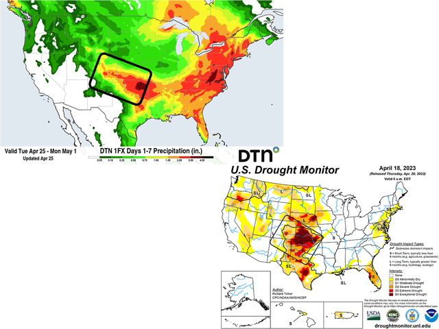
Significant drought has been in the Central and Southern Plains subjectively since fall of 2021. Thanks to La Nina's tendency for a ridge of high pressure and heat during the summer, and a storm track to the north in the winter, drought has been more or less maintained in the region for about 18 months. Even when that broke down this winter and the weather pattern became very active across the country, the region still missed out on most systems, with eastern areas of the Plains getting in on some better showers. Widespread and deep drought has been the result, and much has been written about the effect on forage and winter wheat conditions so far this year. But there is a slight break in the pattern.
An upper-level trough in the central Rockies on the morning of April 25 is starting to produce some showers and thunderstorms over the hardest hit areas of drought, an area that encompasses most of Nebraska and Kansas, eastern Colorado, western Oklahoma, and western Texas. This system will dive into the region on April 26 and showers and thunderstorms will build across the region going into April 27. The result is a forecast for some heavy rain across the deepest drought areas in Kansas, Colorado, western Oklahoma, and the northern Texas Panhandle. Some areas are still going to be left out. But this is the largest coverage area of heavy rainfall this region has seen in about two years.
P[L1] D[0x0] M[300x250] OOP[F] ADUNIT[] T[]
Thunderstorms are going to be a big part of the rainfall that occurs, and models have a tendency to overspread too much precipitation instead of concentrating it in the areas where thunderstorms occur. That means the forecast could be too optimistic about the coverage area for the heavier rains. Some areas within this forecast zone are likely to end up with less than forecast. And some areas may end up with more than the forecast if repeatedly hit by those thunderstorms moving through. But, averaged out, the region expects a wide area of 1-to-2 inches of rainfall with locally more. As a result of crusty surface soils, the Weather Prediction Center, a branch of NOAA, has a good section of these drought areas at risk for flash flooding. You can find those maps here: https://www.wpc.ncep.noaa.gov/….
In addition, another front will move through the region April 28-29, and is forecast to at least bring a chance of additional precipitation to the region. Models are a bit uncertain to the coverage or amounts that may fall with that system. Regardless, dry soils will try and soak up as much precipitation as possible. Sandier soils will allow that to happen more easily, and if rain can be sustained at moderate rates instead of heavy ones, runoff may not be an overtly large concern.
So, if the forecast pans out, will this be able to turn around crop and forage prospects in the region? The short answer is unlikely. Winter wheat conditions in these areas have been extremely poor for a long time. Just yesterday, the USDA updated crop conditions on its Crop Progress report. A summary here -- https://www.dtnpf.com/… -- explains that winter wheat conditions in the U.S. are the lowest in decades. And as far as Kansas, Oklahoma, and Texas are concerned, poor-to-very-poor conditions sit at 62%, 63%, and 55%, respectively. A question on Twitter by Darin D. Fessler asked if the coming rains would have an impact on the current wheat crop. The answers given by those in the region were somewhere between nothing and a little. You can follow that thread here: https://twitter.com/…. That is likely to be the overall case. The wheat crop has gone through some major weather challenges since it was planted last fall. Drought, heat, strong winds, blowing and drifting dust, and frosts have all conspired against this year's crop. However, there are other crops that will benefit from the increased rainfall. Forages should be able to soak in the moisture, and the increased soil moisture will produce good conditions for those yet to plant their spring crops -- at least temporarily.
The drought itself is not likely to show much improvement. The rain is coming too late to affect this week's update that will be released on April 27. Next week's will be more interesting, but unless the storms overperform in a lot of these areas, the drought will remain heavily entrenched in the region. After more than a year and a half of very dry conditions, one system alone will not be able to put much of a dent in the drought. It will take months of above-normal rainfall to do so. California, which was in a similar situation in December, needed more than double the normal precipitation in a season over the entire region to eliminate its drought. It is arguable that the Southern Plains will need more than that.
To find more weather conditions and your local forecast from DTN, head over to https://www.dtnpf.com/…
John Baranick can be reached at john.baranick@dtn.com
(c) Copyright 2023 DTN, LLC. All rights reserved.