

Ag Weather Forum
Major Winter Storm Will Affect Millions This Week
In a very active pattern this winter season, we have seen many storm systems produce heavy snow, blizzards, freezing rain and severe storms. A system this week may lead to the most widespread impacts we have seen since the beginning of the year. That is when California flooded out on New Year's Day and a major winter storm swept through the Plains and Midwest the first few days of the year.
The coming system will occur in several waves and may be hard to discriminate the start and end of the storm system. It begins in the Pacific Northwest Monday night, Feb. 20 into Tuesday. That lead piece will continue eastward through Tuesday and into Wednesday across the Great Lakes. That will mean a few inches of snow across the Northern Plains and Great Lakes areas.
The system will cause a frontal boundary to lie almost west-east from the Kansas-Nebraska border to the southern Midwest.
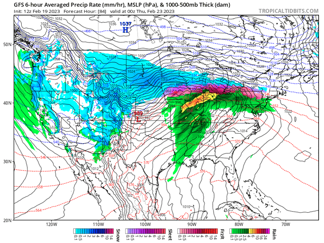
A secondary low that is currently off the coast of southern California Feb. 19 will be drawn eastward Feb. 21-22, making it into the Plains in time to produce at least one line of thunderstorms for the southeastern Plains and into the Mid-Mississippi Valley Wednesday afternoon and evening. Those thunderstorms may have enough strength to become severe. As of Feb. 19, the Storm Prediction Center is focused on an area from Arkansas and northern Louisiana just across the Mississippi River into northern Mississippi and western Tennessee. We may see that area be adjusted as the event draws near, possibly farther north and west.
P[L1] D[0x0] M[300x250] OOP[F] ADUNIT[] T[]
This second system will cause precipitation to increase north of the front across the Midwest, drawing warmer air from the south over the top of it, inducing an area of freezing rain and heavy snow. The prospect for significant icing is still being determined by the models, but the most likely area currently is from central Iowa through New York by Wednesday evening.
The third and final piece to the system will move through the West Feb. 21-22, emerging into the Plains shortly after the second piece on Wednesday evening and should follow that piece of energy eastward from Colorado through New York Feb. 22-23 and moving off the East Coast by early morning on Feb. 24. This part of the storm will have the most access to cold air, producing heavy snow in a wide band from Colorado and Wyoming through the Northeast. Severe weather is not currently expected with this piece, but not impossible and will be watched as it sweeps a cold front through the Plains and Tennessee Valley Feb. 23-24.
That last piece will also be the strongest of the three, increasing winds across the entire country, especially as it is departing the area. Widespread wind gusts of 30-40 mph are expected for much of the Plains and Midwest through the Northeast, while some areas will see wind gusts at greater speeds. We may or may not see that coinciding with the band of heavy snow. If it does, blizzard conditions would be likely, at least for a time. Ground blizzard conditions may occur after the snow ends as well.
Temperatures will fall dramatically after the third piece of energy. Temperatures of 30-40 degrees Fahrenheit below normal are expected in the Northern Plains and Canadian Prairies, though the cold will not be quite as severe farther south and east. That means daytime highs that remain below zero Fahrenheit for a couple of days. Temperatures will moderate over the weekend, making the harsh arctic blast a brief one.
When all is said and done, hazards will lead to all sorts of issues through most of the country outside of the Southeast, which may only see some slightly elevated winds. Heavy icing is favored in a narrow band from Iowa through southern New England with amounts that could eclipse 0.25 inch. Southern Michigan is currently favored for the heaviest icing.
Just north, widespread snowfall amounts of 10-20 inches are expected from southern Alberta and the Northern Plains through the Northeast. There are likely to be many areas that exceed 24 inches.
Southern Minnesota and adjacent areas of South Dakota and Wisconsin are currently favored for the heaviest amounts. Western states will see heavy snow and winds as well, sporadically through the mountains and some higher valleys. Winds may cause issues with blowing and drifting snow along with power outages throughout much of the country. This is a long-lasting winter weather event with many impacts to most of the country.
To find updated radar and analysis from DTN, head over to https://www.dtnpf.com/…
John Baranick can be reached at john.baranick@dtn.com
(c) Copyright 2023 DTN, LLC. All rights reserved.