
Commodities Market Impact Weather
Arctic Air Pouring in This Weekend
MINNEAPOLIS (DTN) –- The return of some very cold temperatures in the U.S. and rain hits and misses in Argentina are the weather factors driving the markets Friday.
HARSH COLD COMING TO MIDWEST
A clipper will bring a strong cold front into the Midwest Friday and Saturday that will send temperatures well below normal. The front will be pushed southward a couple of times by additional systems over the weekend and next week. Each will bring precipitation with them and push the colder air deeper through the region.
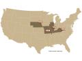
WINTERKILL THREAT FOR CENTRAL AND SOUTHERN PLAINS
P[L1] D[0x0] M[300x250] OOP[F] ADUNIT[] T[]
A front will move into the Central and Southern Plains this weekend and may provide some additional showers, including some heavier snow across the far north. Temperatures will fall dramatically behind the front and could cause additional stress to livestock and winterkill on any exposed wheat. Another system should form along the front Tuesday and Wednesday with more wintry weather for far southern areas, which may be beneficially heavy in some areas.
ARCTIC COLD SETTLING INTO NORTHERN PLAINS AND CANADIAN PRAIRIES
A strong cold front will bring some snow, especially near the mountains and across the far south, and arctic air into the Canadian Prairies and Northern Plains for the next week. Both should lead to increased stress for livestock. The region may get a bit of a reprieve late next week before more cold is expected to move in the following week.
WATER LEVELS STILL HIGHER ON LOWER MISSISSIPPI
Recent precipitation has been able to keep water levels on the Lower Mississippi River from falling into dangerously low territory. The watershed has been active and will stay active with several rounds of precipitation moving through into February, which should keep river levels up for a while yet.
RAIN IN BRAZIL DELAYING SOYBEAN HARVEST
A front moves into southern Brazil on Friday and continues with showers through this weekend and into next week, which would be helpful for filling corn and soybeans. Widespread precipitation elsewhere continues to favor later-planted soybeans, but is delaying harvest. If the wetness continues too long, it may push back the safrinha corn planting schedule, which would not be an ideal scenario for the crop.
RAIN FOR ARGENTINA LOWER AFTER FRIDAY
A couple of fronts have brought scattered showers through Argentina this week, adding to good totals from last week. The main front lifts north on Friday with some lingering rain in the northwest over the weekend. Early-planted corn, which is filling, will only be stabilized by the showers. Another front will move through in the middle of next week for the next chance of rain. Some stabilization has already taken place, but a stark turnaround has not happened and is unlikely to occur. Still, the rain will keep conditions from getting worse for a little while at least.
John Baranick can be reached at john.baranick@dtn.com
(c) Copyright 2023 DTN, LLC. All rights reserved.