
South America Calling
La Nina Impact on South America Means January Forecast is More of the Same
La Nina may be taking a break in the Northern Hemisphere in January, (see: https://www.dtnpf.com/…) but it continues its strong influence on South America.
La Nina usually creates a hotter and drier summer in southern Brazil and Argentina and, so far, has been doing so. As we head into January and a new calendar year, the effect looks to continue at an increasingly inopportune time.
Earlier this season, warmer and drier conditions have had some effect on crop health and delayed planting in Argentina. With planting nearly completed in southern Brazil and accelerating in Argentina, more and more of this season's crop is being subjected to the unfortunate weather.
According to the Buenos Aires Grain Exchange, 63% of Argentina's corn and 72% of their soybeans have been planted as of Dec. 29. That is still behind the average pace of 78% and 86%, respectively, but it is a majority of the crop. Some of the early corn is pollinating and needs more rain. The newly planted and developing crop need more rain for even germination and sustained growth.
P[L1] D[0x0] M[300x250] OOP[F] ADUNIT[] T[]
January usually has some dry spells. And, being in the middle of the summer, it gets very hot when precipitation is not around. Daytime highs are typically in the 30s Celsius (middle 80s to upper 90s Fahrenheit), but could be higher during these drier stretches, pushing closer to 40 C (104 F).
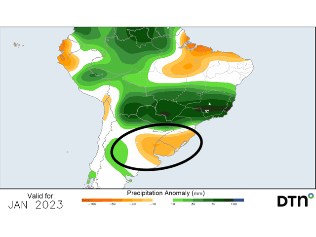
Even so, this coming January may be warmer than normal. Long-range versions of both the American Global Forecast System (GFS) model and European Centre for Medium-Range Weather Forecasting (ECMWF) model point to both warmer and drier-than-normal conditions for the majority of the month from Rio Grande do Sul, Brazil and southern Paraguay south through all of Argentina's primary growing area. In a month that typically goes drier for a period, the coming warmth and dryness is not a favorable combination.
That is especially true as soil moisture continues to be well-below normal for this time of year across the entire region. There is little subsoil moisture for crops to draw from. And young plants just starting out will not have access to that moisture as their root systems are too shallow.
The month will not be entirely dry, though. Systems will still move through. One is going to move through the first few days of the month. But it gets dry behind the front that pushes through and showers do not return until the next front comes through. These fronts have been coming at a pace of about once per week, which looks to continue for most of the month.
Showers with these fronts are scattered and not consistently moderate or heavy, leaving some areas with little to go on before the next front moves through the following week.
Overall, it's a poor weather situation that will stay poor for at least another month. The weather just does not seem to be wanting to cooperate, thanks to La Nina.
To find more international weather conditions and your local forecast from DTN, visit https://www.dtnpf.com/….
John Baranick can be reached at john.baranick@dtn.com
(c) Copyright 2023 DTN, LLC. All rights reserved.