

Ag Weather Forum
Heavy Snow, Blizzard Conditions, and Severe Weather Expected Early Next Week
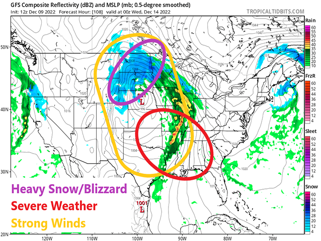
A very strong storm system will move through the country next week. The system will have access to plenty of moisture, creating heavy snow across the Northern Plains, and widespread precipitation elsewhere, including chances for severe weather across the South. Strong winds with the system will lead to blowing dust in the drought areas in the southwestern Plains, and bring blizzard conditions to the heavy snow areas in the Northern Plains. Overall, this system is going to create widespread hazards for much of the country.
The cause of this system is a developing ridge of high pressure in the upper atmosphere over Greenland and northeast Canada. The ridge will act as a block in the flow, causing storm systems to cut underneath it across the U.S. One such storm system is starting to organize itself already in the western states. That storm will move east of the Rockies on Monday and find access to a lot of moisture from the Gulf of Mexico.
The low itself will quickly wrap up in the Northern Plains Monday night and Tuesday and as it does so, will pull a lot of that moisture back around it across the region. Temperatures will be low enough for this to be a snow event and, given the amount of moisture it will pull in, will be a heavy snow event. As of midday Friday, models are suggesting amounts in the 1- to 2-foot range across the Dakotas. Northwestern Nebraska, and parts of Wyoming, eastern Montana, and northern Minnesota will get in on the heavier snow as well.
Winds will be strong with the storm system. Up and down the Plains, winds on Monday are likely to be in the 40-55 mph range but as the snow gets going over the Northern Plains, we could see some gusts exceeding 60 mph Tuesday and Wednesday. The wind speed threat is still being determined, but it will be difficult to measure the snow with any sort of accuracy. The snow will wind down on Wednesday, but the system could continue snow showers through Friday before they finally leave.
P[L1] D[0x0] M[300x250] OOP[F] ADUNIT[] T[]
To the south, the cold front to the system will race across the Plains on Tuesday and as it does so, will encounter an environment ripe for severe weather. Currently, the highest risks will be from eastern Kansas and Missouri southward to the Gulf of Mexico on Tuesday, and from Tennessee southward on Wednesday. All modes of severe weather will be possible.
Temperatures out ahead of the system will be rising through the weekend and early next week. Highs up to 50 degrees could reach as far north as Interstate-80.
But the cold front coming through will quickly push those temperatures back down below normal for the rest of the week. Up in the Northern Plains, where snowfall is the heaviest, temperatures could fall below zero yet again.
Precipitation will be widespread with the system. Of course, it will not be even over the country, but widespread amounts of 1 to 2 inches are expected, heavier down south with the thunderstorms. The precipitation will help to keep water levels in the Mississippi River from falling lower and should ease drought in a lot of areas.
However, not every area will see the good moisture. Some areas in the Midwest will see less than an inch and the southwestern Plains is going to find it difficult to see any precipitation. From western Kansas down through west Texas and back to the Rockies, there just will not be much moisture for the front to work with as it moves through. These areas, which are already very dry, may instead see blowing dust as the winds whip through the region, and increasing drought.
Models have been remarkably consistent with how this storm will develop, though of course some changes may be possible over the coming days. Still, this is shaping up to be a very significant December storm system.
To find updated radar and analysis from DTN, head over to https://www.dtnpf.com/…
John Baranick can be reached at john.baranick@dtn.com
(c) Copyright 2022 DTN, LLC. All rights reserved.