

Ag Weather Forum
Severe Thunderstorms in the South Tuesday
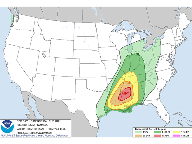
The Storm Prediction Center (SPC) has issued a Moderate Risk of severe weather across Mississippi with slight risks for the Delta region, as well as portions of the Tennessee Valley and Southeast for today. This could include large hail, damaging winds, and possible long-track tornadoes.
This is because a deep upper-level trough in the West is being opposed by an upper-level ridge developing in the Southeast. The difference between the two is likely to produce the strong thunderstorms across the Southern U.S.
Thunderstorms are already developing early this morning in the Lower Mississippi Valley. Those are developing well ahead of a strong cold front that is pushing through the Plains and Upper Midwest.
P[L1] D[0x0] M[300x250] OOP[F] ADUNIT[] T[]
Very warm and moist air is being transported northward from the Gulf of Mexico and will help develop additional thunderstorms throughout the rest of the day.
Some of the early thunderstorms are likely elevated. Without access to ground-level moisture, the storms are not expected to be severe. But given time and additional heating, they may start to become severe by the noon hour. These storms will have access to all the surface moisture and heat, as well as increasing upper-level support to produce large hail, damaging winds, and tornadoes. According to the SPC, the tornadoes may be significantly strong and long-lived. As of 9:30 a.m. CST, the Center has yet to produce a Severe Thunderstorm or Tornado Watch.
Multiple lines and clusters of thunderstorms will be possible throughout the day, however, and the threat for severe weather will continue well into the evening as the front does not enter the region until the evening hours. Locations could be hit multiple times by strong or severe thunderstorms.
Storms will conglomerate more into clusters and lines, changing the threat over to mostly wind damage by the evening and possibly into overnight.
The greatest threats are where the heat, humidity, and timing are all the best for thunderstorms and the front, which will be centered around the state of Mississippi. However, strong thunderstorms may also occur as far west as extreme eastern Texas, up to the Ohio River and east through Alabama. The timing is also best between 2 and 7 p.m. CST but may occur well before or after that as well.
Deep storm systems often bring risks of severe weather to the southern states in the winter, but the inclusion of a Moderate Risk by the SPC, as well as the potential for long-track tornadoes. should give those living in the area an extra degree of weather awareness today.
John Baranick can be reached at john.baranick@dtn.com
(c) Copyright 2022 DTN, LLC. All rights reserved.