

Ag Weather Forum
Planting Weather Windows in South and East Open Briefly
MINNEAPOLIS (DTN) -- Planting progress was slow for another week as wet weather kept equipment in the shed for a lot of folks.
According to the latest USDA NASS Crop Progress report released on Monday, May 9, only single-digit progress was made in corn (22% planted versus 14% last week), soybeans (12% planted versus 8% last week), and spring wheat (27% planted versus 19% last week). That puts all three major commodities well behind the five-year average pace of 50%, 24% and 47%, respectively. (See https://www.dtnpf.com/…)
For corn and soybeans, the only major production states within a few percentage points or ahead of the five-year average are located in the Central Plains or South -- Kansas, North Carolina, Tennessee, Texas for corn; Arkansas, Kansas, Kentucky, Louisiana, Mississippi, Nebraska, North Carolina, Tennessee for soybeans. The others across the Corn Belt are well behind pace. The slow pace is due to either cold, wetness, or a combination of both, that has been the pattern during the last several weeks.
P[L1] D[0x0] M[300x250] OOP[F] ADUNIT[] T[]
For spring wheat, it is mostly North Dakota that is the laggard; the state produces roughly half of all hard red spring wheat on average. That state has only planted 8% of its acreage compared to its five-year average of 37%. Minnesota, at only 2% planted, is also trailing its five-year average of 50% quite significantly. Extreme wetness across both states caused the delay.
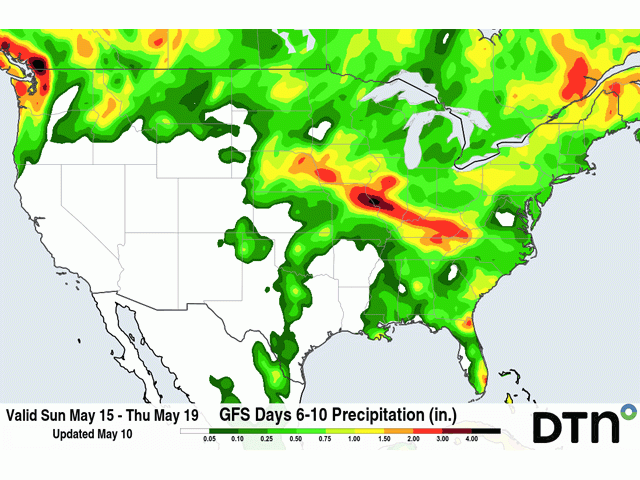
The weather this week offers a bit of a reprieve for some of these states that are behind schedule. An upper-level ridge of high pressure has built in across much of the eastern half of the country, keeping it rather hot and dry. The combination is good for draining soils and planting. With lots of soil moisture still around, the combination is also good for germination and emergence, which is also behind schedule.
However, an upper-level trough of low pressure has parked itself across western states. While keeping it cooler, it is also providing multiple opportunities for showers and thunderstorms during the next several days. That should continue to improve drought conditions for a lot of the Pacific Northwest, Northern Plains, and Canadian Prairies, but will also keep equipment out of the fields. Almost daily showers and thunderstorms are expected in these areas but also at times into Nebraska, Minnesota, Iowa and Wisconsin through May 13. Outside of these states, the open opportunity to plant is likely to be taken by those that have had to delay their plans already, especially in the "I" states of Iowa, Illinois and Indiana.
The window will not last long, however, so those planning to act will likely need to do so quickly. The western trough will gather enough energy to push the eastern ridge off the East Coast this weekend, sending a storm system and its cold front through the country with scattered showers. Several days of showers will make planting progress difficult for some farmers.
Behind that system, a ridge will develop in the West and cause some drying in the Northern Plains. But it will be only brief. The ridge will spread across the southern half of the country next week but be weak across the north. That will allow for smaller disturbances to ride over the top of it, creating more showers and thunderstorms for the northern tier of the country, including the majority of the Corn Belt states. Models disagree on timing, extent and intensity of any potential showers, but the overall picture should point to some more delays, at least locally, to cool down the rapid pace expected this week. It will also make it more difficult for those in the northwestern Corn Belt, specifically the Dakotas and Minnesota that are already well behind, to find more wide-open windows for progress.
Farther south, the pattern this week may offer some limited beneficial rainfall for winter wheat. Suffering in drought since it was planted last fall, wheat has had little precipitation to utilize. Winds, heat and drought have combined to create rather poor winter wheat conditions for the major production areas from western Kansas all the way through west Texas back to the Rockies.
The trough in the West will send some limited upper-air support to produce isolated showers and thunderstorms each day from May 10 through May 15 before those chances dwindle. Though they will come with elevated risks of severe weather each day, soil moisture may improve temporarily to stabilize wheat plants getting closer to or further through reproductive stages of development. Indications are that although the individual thunderstorms will be heavy where they pass through, they will create only streaks of heavy rainfall across the landscape, while most areas will, unfortunately, be missed.
To find more regional weather conditions and your local forecast from DTN, head over to https://www.dtnpf.com/… John Baranick can be reached at john.baranick@dtn.com
(c) Copyright 2022 DTN, LLC. All rights reserved.