
Ag Weather Forum
March Goes Out Like a Lion With Possible Severe Weather
We are entering the last few days of March and it anything like the old saying of "in like a lion and out like a lamb." Normally this is meant to describe how March can start out quite rough and wintry, but end much more tranquil and warm. Much of the month has been characterized with up-and-down temperatures, heavy precipitation events, and some severe weather. For the last few days of March, the lion-like pattern continues instead of subsides.
Temperatures are not as extreme as they were earlier in the month. And the ones that follow a strong system this week will not be very cold either, but very warm air ahead of it will induce a strong temperature gradient that will increase upper-level winds and feed stronger storms.
Typical of spring, that will result in severe weather across the southern tier of the country. The Storm Prediction Center has a three-day severe weather risk from the Plains eastward March 29-31. Storms will develop from Texas all the way up into Iowa in the late afternoon and early evening of March 29.
These storms will be characterized with strong wind and hail threats. A few tornadoes will be possible in the developing storms as well, mostly in portions of Texas and eastern Oklahoma where storms are likely to be stronger and surface-based. Through the overnight hours, these storms are forecast to congeal into a line of strong thunderstorms that will continue eastward overnight.
P[L1] D[0x0] M[300x250] OOP[F] ADUNIT[] T[]
With increasing moisture and strong upper-level winds, the southern-flank will strengthen and continue eastward through March 30. This day will have the greatest risk of a widespread severe weather event. With the line of storms, strong winds are the main hazard, but there will be a significant risk of embedded tornadoes within that line as well. It may be difficult for folks to distinguish whether a tornado moved through, or just strong straight-line winds.
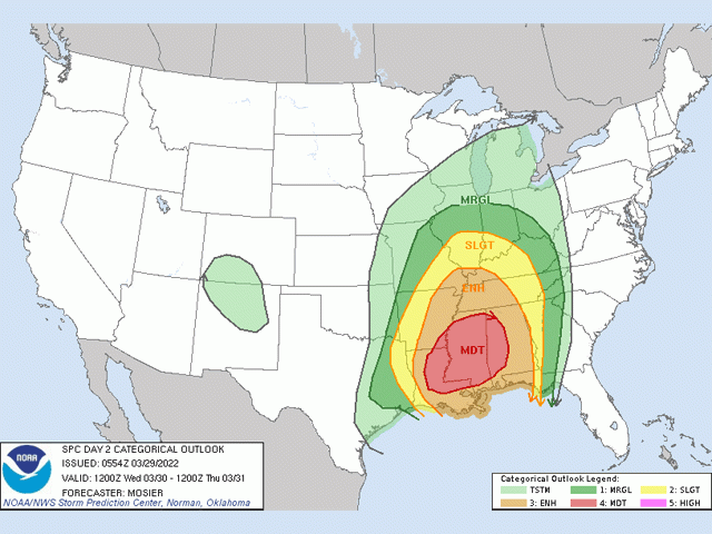
The Storm Prediction Center has outlined a "moderate risk" of severe weather from eastern Louisiana into western Alabama and a slight risk extending west to eastern Texas, north to central Illinois, and east into Georgia as this line moves through.
Day-2 moderate risks are fairly rare, but the setup with this system is very good and consistently forecast by models. This is an area that received strong storms and tornadoes last week and another round of severe weather would compound cleanup efforts.
Storms will continue through the Southeast on March 31. While the line of storms will likely lose some energy from the previous night's worth of severe weather, it may continue, especially if it survives into the afternoon across Georgia and the Carolinas where damaging winds would be the primary threat.
Severe storms may form farther north in the Mid-Atlantic region as well. Early storms from the night before could still be strong in the morning, but the larger threat is during the afternoon and evening as the main cold front from the system moves through. If storms do develop, damaging winds would be the primary threat.
Outside of thunderstorms, winds are likely to be strong as well. Across West Texas and adjacent areas, wind gusts may exceed 60 miles per hour during the afternoon of March 29. Elsewhere east of the Rockies, winds will continue to gust up to 45 mph as the main storm system tracks eastward on March 30 and 31.
Wintry, mixed precipitation will occur mostly on the northern side of the storm across the Northern Plains and northern Midwest. A few inches of snow will be possible along with potential for freezing rain in northern Wisconsin and much of Michigan.
Will March be out like a lamb? I think not.
To find more regional weather conditions and your local forecast from DTN, head over to https://www.dtnpf.com/…
John Baranick can be reached at john.baranick@dtn.com
(c) Copyright 2022 DTN, LLC. All rights reserved.