

Ag Weather Forum
A Look at Spring Flood Risk
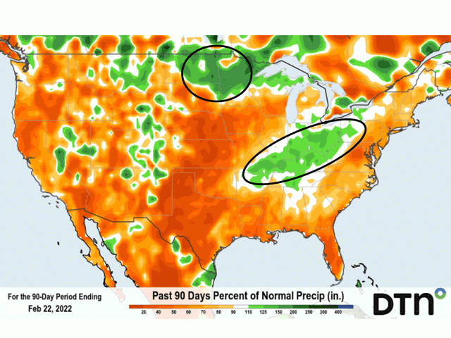
Here's how precipitation totals look over the past 90 days:
In the Red River Valley of the North, DTN precipitation analysis indicates that precipitation over the past 90 days, going back to late November 2021, amounts to between 150% and 250% of average -- in other words, from 50% to 150% greater than average. Given the wide, flat characteristic of the northern Red River, along with its flow direction going north toward Lake Winnipeg in Manitoba, Canada, those differences versus average place the Red River into a notable flood risk.
The Eastern North Dakota-Grand Forks National Weather Service (NWS) office included this comment about major flood potential in a hydrologic outlook issued Thursday, Feb. 24:
"There is a high risk (greater than 65% chance) of major flooding at Fargo/Moorhead, Oslo, and Pembina on the Red River. In North Dakota, there is a high risk of major flooding at Harwood on the Sheyenne River and Abercrombie on the Wild Rice River. There is a medium risk (35 to 65% chance) of major flooding at Grand Forks/East Grand Forks and Drayton on the Red River. In North Dakota, there is a medium risk of major flooding at Valley City, Kindred, and the West Fargo Diversion on the Sheyenne River."
P[L1] D[0x0] M[300x250] OOP[F] ADUNIT[] T[]
In the Ohio River basin, the NWS forecast office in Wilmington, Ohio, posted these details on Wednesday, Feb. 23:
"Flood potential for the next 90 days is above normal for much of the Ohio Valley. This means at least minor to moderate flooding is possible across portions of the Ohio Valley. Isolated major flooding cannot be ruled out into April. Precipitation the last 30 days has averaged 2 to 8 inches with isolated totals higher and lower. Normal for this period is near 2-2.5 inches. Therefore, most of the basin is 100%-400% of normal precipitation. The heaviest precipitation is focused in Tennessee, Kentucky, southern Illinois, southern Indiana and southern Ohio. 90-day (forecast): An active pattern looks to continue from March into April before it begins to dry out some in May. Therefore, flood risk is elevated until May in much of the Ohio River basin."
Soil moisture for late February in the Ohio River basin is listed as above normal in all the basin states (southeast Illinois, Indiana, Ohio, western Pennsylvania, Kentucky, Tennessee) except for West Virginia, which is noted as near normal.
The U.S. Geologic Survey also notes above-normal stream flows in all these basin states and portions of states, as well, except for, again, West Virginia at near normal.
Seasonal forecasts for these two areas have some differences. The Red River basin is indicated to have near- to below-normal precipitation for the entire March-April-May time period. Such a trend would mean reduced flooding threat and more favorable fieldwork and planting conditions.
Meanwhile, the Ohio River basin has widespread above-normal precipitation to expect during this time, especially during March when precipitation totals may surpass 2 inches above the normal totals. Such a trend would keep soils wet and threaten to cause flooding in the region.
Bryce Anderson can be reached at Bryce.anderson@dtn.com
Follow him on Twitter @BAndersonDTN
(c) Copyright 2022 DTN, LLC. All rights reserved.