

DTN Long-Range Weather Outlook
Weather Outlook Through Summer 2022
Note: At the DTN Ag Summit in Chicago on Dec. 7, I presented an early look at the weather conditions DTN is forecasting through August. Below is a highlight of the important things to expect during the next six to eight months. But there is not enough space in this blog to talk about all conditions across all areas throughout the entire year. To get more specific information on DTN's long-range forecast, sign up for a free trial at https://www.dtn.com/….
**
La Nina -- it is the feature that never went away. The 2021 growing season was influenced in the beginning by its presence in the equatorial Pacific Ocean, and while it faded in the spring and summer, it returned in the fall.
The 2022 season is seeing something similar. That does not mean it will be a copy-cat year. No two La Ninas are the same and there are some differences that are and will be important. But the impact of La Nina this winter and spring will set up the 2022 season. It, too, is forecast to fade this coming spring and will likely be in a neutral state through summer, with waning influence with time.
It should be noted the weather that occurs during the growing season is more important than the weather that occurs before it. But getting below-normal precipitation during the growing season is different if you started out with wet soils in the early spring, or with drought. The Plains during the 2021 season highlights that fact quite well as below-normal precipitation, on the whole, was recorded from May through August from North Dakota through Kansas. But with good rainfall to start out the year in the south, yields turned out much better in Nebraska and Kansas than in the Dakotas.
DROUGHT AREAS
This year, we start with drought across the Plains yet again. It is not in the same location with the same intensities as a year ago, but the overall picture of poor soil moisture starts off this year.
That contrasts with much better soil moisture across the Eastern Corn Belt. Drought is much worse in the Delta and Pacific Northwest now than it was a year ago as well.
During winter, La Nina typically leads to near-normal precipitation across the Northern Plains, drought across the Southern Plains, and enhanced precipitation across the Pacific Northwest and Ohio Valley. DTN favors this pattern overall for the next two to three months. We should see drought continuing to increase across the Southern Plains, hold in the Central and Northern Plains, and likely diminish in the Pacific Northwest.
The Delta will be in a tough spot. La Nina tends to favor dryness in this region, especially farther south, but the DTN forecast is calling for above-normal precipitation. It may be in just the right spot to eke out better rainfall and ease the drought that has built up in recent weeks.
CLOSER LOOK AT TEMPERATURES
P[L1] D[0x0] M[300x250] OOP[F] ADUNIT[] T[]
Temperatures thus far this winter have been very up and down. Most of December was very warm, but the polar vortex started to show up in western North America toward the end of the month and pushed through the majority of the country in a couple of spurts for early January.
The pattern shapes up to continue this trend for the end of January, but we may see a pattern more like we saw in late December for February. That is, higher temperatures would be found across the southern and eastern U.S. while low temperatures build up in Western Canada into the Northern Plains. Perhaps we will see some of that cold pushing through the northern tier of the country at times as well. And a similar pattern looks to be in the cards through March, April, and potentially May as La Nina lingers, slowly dissipating toward an expected neutral state. That could bring about some late frost risks, especially in the Northern Plains through the northern Midwest.
SPRING PRECIPITATION
For precipitation during the spring, with the waning influence of La Nina expected, more sub-seasonal weather factors are likely to have a strong influence over the weather. These sub-seasonal factors, (things like snow cover, soil moisture, cloud cover, thunderstorms in the western tropical Pacific Ocean, among others) are very hard to predict more than a couple of weeks out, so there is greater uncertainty with the spring forecast.
Given that, dryness looks to be a feature for the Plains. Drought conditions that are likely to be in place for the end of winter are also likely to worsen in spring. Meanwhile, precipitation across the Eastern Corn Belt and Delta are forecast to be above normal and soils may be too wet and possibly too cold to plant early and the frost risks I mentioned earlier may be enough for some producers to hold off on planting too early.
NEUTRAL LA NINA IN SUMMER
During the summer season, though, La Nina should be in a neutral state. Whether that is on the cold side of neutral or the warm side of neutral is up for debate. If anything, trends have been to keep it on the colder side of neutral through the summer. Either way, those sub-seasonal factors will have a great influence on our weather patterns throughout North America.
With so much uncertainty, it becomes difficult to trust models, especially at face value.
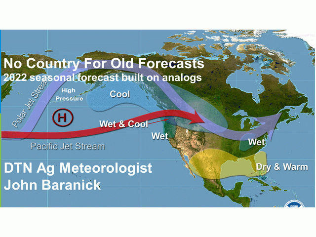
Therefore, at DTN we use a different approach. We use what are called "analogs" to help guide our forecast. Simply put, analogs are conditions in the past that have similar features to what we are currently seeing. We can take a look at ocean temperatures and their trends across a wide area of the globe and pick out years where we see similar conditions to where we are currently. Then, we can use what happened in those years to help us with our forecast.
For example, if we think the conditions in January 2001 were similar to what we are seeing in January 2022, we can take a look at what actually happened in March through August of 2001 and use those values to make a forecast for March through August of 2022.
Hopefully there are multiple years in our database that look similar enough to blend them together to make a good forecast. The science is not exact, as no two years are 100% the same. That is why our team of weather forecasters is so important, giving weight to certain years over others, and using their experience to find the meaningful patterns and risks and putting them into the forecast.
SUMMER CONDITIONS
Relying more heavily on analogs, the summer season does not offer much in the way of beneficial conditions across the majority of the country. Outside of the Southeast, conditions are likely to be very warm and dry on average for June, July and August. For those in the Plains that are likely to be in drought once the summer hits, we could be looking at another year of poor conditions in the Dakotas and Minnesota, and potentially worse for Nebraska and Kansas than last year.
Good rains in the Eastern Corn Belt during the spring may have to carry crops through their reproductive stages in the summer with more limited opportunities. There is also a risk of more regional drought developing east of the Mississippi River with less consistent and below-normal intensity with the showers. Of course, our confidence in that scenario is not large. And a big swing in the ocean temperatures is possible, which would ruin this forecast for sure. But that is what it looks like now with the information we have.
REGIONAL LONG-RANGE FORECASTS
So, recapping some of the major points in the long-range forecast as an early look to the 2022 growing season, the Southern Plains look to be the area with the highest concern. That is especially true for hard-red winter wheat and livestock as the area deals with increasing drought from the winter right through summer.
The Central and Northern Plains are unlikely to see drought going away during spring, though drought is not as bad there now as it was a year ago outside of Montana. But warmer and drier conditions during the summer could hurt wheat, corn and soybean production yet again.
In the Eastern Corn Belt, wetter conditions should leave springtime with ample moisture, but occasional cold shots and late frosts could push corn and soybean planting back a bit. Iowa and Minnesota seem to be on the drier side of those conditions. Soft-red winter wheat should have pretty good conditions, however. Then regional drought may start to show up in the summer that could put some of the crop areas in trouble going through reproduction and grain-fill.
The Pacific Northwest is still in drought, which is worse than last year at this time, but recent and forecast precipitation should bring soil moisture into a reasonably favorable spot for spring as winter wheat awakens from dormancy and spring wheat is planted. Drier conditions and a couple of hot spells could cause those early favorable conditions to decline through the summer for spring wheat, however.
The Delta region is a bit more uncertain than the others as models are not jiving with what we typically see during La Nina and drought that is there already is a concern if the models are wrong for spring. Conditions may turn out to be alright in the summer, though, as there is at least some signal for above-normal precipitation in the latter half of summer, just in time for soybean fill.
And the Southeast may be in the best shape overall. There is some limited drought there now, and outside of a possibly dry spring, conditions during the summer should be good for pastures and cotton.
John Baranick can be reached at john.baranick@dtn.com
(c) Copyright 2022 DTN, LLC. All rights reserved.